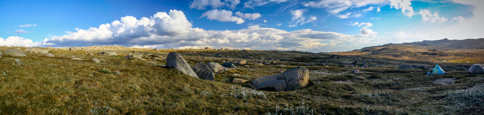
The High country is a wonderful place at any time of year. Summer is especially nice as even if it is 40degrees in Melbourne, up on the high plains it can be more like 25. Although being the high country the weather can change very quickly.
This trip was a boys trip being just me and our oldest son along with some close friends and was planned to be a more relaxed one. Our chosen location was near the Dargo high plains road not all that far from Blue rag. The plan was to do 1 or 2 day trips and then sunset up the top of the Blue rag track for new years eve.
The 1st night saw a thunderstorm and plenty of wind but we were nice and comfy in the campers. The next couple of days were mostly completely clouded in so some exploring near camp and sitting by the fire were in order (once we got one going in the dampness).
fogged in
There is so much to see in this area of the country so any trip will only scratch the surface. One day trip saw us heading down towards the Dargo river visiting harrisons cut for a quick lunch of pies before heading up to Grant and exploring the Union mine. On the way back to camp we stopped to check out Treasures hut. the old hut in the photo below is no longer used but there is a newer one that is still used by the treasure family when bringing the cattle down from the high plains.
The next day ended up being another relaxing day around camp with only a very short excursion to lankey plains hut. The rest of the day was spent eating to many nibbles and planning future trips.
Lankey plains hut
Our final outing for the trip was to Blue rag Trig point for sunset we ended up doing this on 30th as the weather for new years eve was looking fairly ordinary.
What a wonderful way to spend an afternoon and early evening. Blue rage track while nowhere near as hard as it once was, is still a steep and at times a bit loose. The view is amazing, sitting up there with cheese, dips and drinks its a tough life but someone has to do it.
Sunset from Blue rag trig point
A great and relaxing trip only a few hours from Melbourne.
I don’t think I will ever get tired of exploring the snowy mountains area and this overnight trip to Mt Kosciuszko via Mt Stillwell and the old chairlift ruins.
This trip was done as part of an organised guided trip where all camping equipment and food was provided and the camp even set up for us.
Not having to carry your tent and sleeping gear certainly makes life a lot easier!!
The trip started at Charlottes Pass and followed the ridgeline track above the main Mt Kosciuszko track to Mt Stillwell. a reasonably easy walk with great views from the top spanning from Mt Kosciuszko to Blue Lake and back to Charlottes pass.
View from Mt Stillwell
From there we left the track and headed for the old Mt Stillwell restaurant site for lunch. The restaurant was built in 1964 at the highest point of the Thredbo valley to Charlottes pass chairlift which was at the time the longest in the world.
The chairlift was closed and the restaurant abandoned after someone died from exposure on the chairlift.
Mt Stillwell restaurant and chairlift site
The old structures are amazing to see and the advantage of it being a guided trip is learning about the history from the guide.
After lunch we headed to our camp near Merrits creek where drinks and nibbles were waiting. Camping up here above the treeline on the open high plain is just wow, it feels different exposed but comfortable where you can just sit back and forget about the world outside this natural wilderness.
The weather this 1st day was perfect, Mostly sunny and light winds.
Sunday morning the clouds looked more ominous the conversation was that we may get a bit wet later in the day. So after a nice breakfast we were off again back towards the main track to Kosciuszko and then up to seaman’s hut.
Morning view from our campSeamans Hut
By the time we reached Seamans hut the cloud had really descended onto the range.
When spending time up in the high country you do need to be prepared for all types of weather as it can change very quickly. One minute it will be nice and sunny, but as soon as the cloud comes over the temperature drops significantly..
We spent a little time here checking out the hut and surrounds before walking the last stretch to the top of Mt Kosciuszko (highest point in Australia). While it is not a steep or big climb from the surrounding High areas, do not underestimate the altitude if you are not used to it. The lower air pressure will have an effect on you ability to do normal physical activities before being out of breath.
The normal view from the top was a bit more restricted today by the low cloud but even with the inclement weather it is still a great place to be.
limited view from the top
Despite the weather, we all had a relaxing and enjoyable lunch before starting on the main track back downhill and towards Thredbo where we would be picked up.
One of the highlights on the track from Thredbo, is Lake Cootapatamba in the valley below Mt Kosciuszko and Cootapatamba Hut near the lake.
Lake CootapatambaCootapatamba Hut (credit Kosciuszko huts assoc)
This hut was built in 1952 and served as an emergency shelter for hydrologists working on the snowy hydro system in the winter months. There is actually a ladder to the top of the chimney and a hatch so people can climb in through the chimney in the winter as the hut is often almost completely buried by snow.
The walk from the top of Mt Kosciuszko to the top of the chairlift at Thredbo is a relaxing mostly gentle downhill walk of 6.5km, about half of which is raised walkway to protect the natural ground cover.
A short 12min ride down the chairlift before being picked up and taken back to our cars.
Another great weekend trip to an amazing natural area. I highly recommend exploring this area if you ever get the chance.
I am not a fan of crowds, trying to squeeze through the masses of terrorists …. I mean tourists to get a glimpse of the attraction is not my idea of fun so for this weekend trip I decided to follow a different route through Litchfield NP.
Instead of heading down to Batchelor to follow the main road into the park, I turned off earlier on the road to Berry Springs and then on to the Litchfield park road.
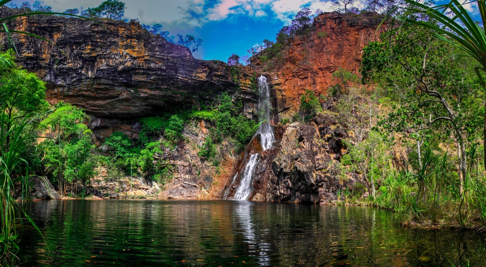
This directions brings you to the last of the major tourist attractions Wangi falls 1st so if you get a reasonably early start from Darwin there should not be to many people there and before the tour busses as it was for me on this trip.
When flowing Heavily after the wet season, the falls are amazing and even i the middle of the dry season as below, are still pretty good.
From here instead of following the main road to all the other touristy falls and sights, I headed south and turned on to the Reynolds River track. The track runs south through the park all the way to the Daily River road and being a 4wd track does not see anywhere as many people as the main areas.
Not far along the track is the turn off to Blyth homestead.
This side track is definitely 4wd only as there is a creek crossing that almost always has water in it. not deep or difficult but more than a car can manage.
Blyth Homestead was built by the Sargent family in 1929 abandoned in the early 1960s. You can explore the site and get an idea of the tough conditions faced by early settlers. There are also the ruins of an old tin mine here.
After exploring the site it was back on to the main Reynolds River track and south towards Sandy creek falls where we would camp for the night.
The camping area is basic but has toilets. From the camp site it is a 3.2km return walk to Sandy creek falls, while not a big as Wangi falls is still quite beautiful and every time I have been there I have had the place to myself.
I love this picture and have a big one on a wall at home.
Sandy creek fallstrack to sandy creek falls
As always a nice quiet night with only one other vehicle camped here even though it is the middle of tourist season.
In the morning after a slow start it was off to Surprise creek falls. The drive is very picturesque with plains full of huge termite mounds and a couple of almost dry creek crossings before turning off to Surprise creek just before the Reynolds river crossing.
This place is awesome!!! A short walk from the carpark to the base of the falls where the small waterfall steps down through 2 very deep waterholes in the rock. These are crystal clear and deep and great to jump into from the next level up. I spent quite a bit of time here and again had the place all to myself until just before it was time to leave.
It is worth the drive just for this spot alone and I have been back here again and again.
Surprise creek falls
Just after leaving Surprise creek you come to the crossing of the Reynolds river. Depending on the time of year it can be anywhere from impassable to completely dry. On this trip the crossing only had a small amount of water in it which made it a lot easier to pick a line through and around the trees on a bank in the middle of the river.
After the crossing it is a straightforward run down to the Daily River road and then east towards Dorat road and north to Adelaide river. The Adelaide River Inn is a nice place to stop for lunch or dinner and a drink(for the non drivers) on the way home.
It is then just a 1 hour dive back to Darwin up the Stuart hwy.
This trip can be done in one day but much better to take your time over two and do more exploring.
This was a trip I did back in 2007. Alpine climbing was always something and still is something I have been fascinated in doing and this course was I thought a good introduction and a way to learn some skills.
After arriving in Wanaka and getting to the accommodation, it was off the the climbing companies office to get the gear sorted before the start of the trip in the morning. This was making sure I had all the climbing equipment I needed, getting climbing boots and crampons (supplied by the company).
That afternoon I wandered around Wanaka checking the place out. Even in summer it is a great place where you can relax or do one of many outdoor activities based in town.
The next morning we left Wanaka and drove to Fox glacier where we were to take a helicopter up to Pioneer Hut on the edge of the Glacier. Even the drive just to get to Fox Glacier is spectacular, passing mountains, waterfalls beside the road, then coastal views on the way up the west coast.
On arrival at the helicopter base the weather had turned very grey which was preventing us being able to fly up to the hut so after getting the gear all packed in the chopper ready to go, we headed into town for some lunch.
View from chopper base to Fox Glacier
After lunch the weather had cleared enough to take off so up we went for a short but awesome flight tracking up the glacier, between the peaks on either side until we reached pioneer hut.
What a great place to be…… sitting on a rock ledge on the edge of the glacier, Pioneer hut is a simple but solid hut to keep climbers safe and warm in the mountains and the views from the front deck are great.
Pioneer hut with Fox glacier behindinside Pioneer hut
The rest of the day was spent organising gear for the next day, relaxing and getting to know the other people on the course.
The next day we headed out for some skills training. This included self arresting with the ice axe, crampon skills, ropes skills including crevasse rescue techniques.Glacier area for skills training
The weather was excellent this day and provided the opportunity for some photos in the afternoon.
on the 3rd day of the trip we woke to some more bad weather, cloud completely surrounded the hut and could barely see the toilet only 20m away.
But not to waste a day we instead built a snow cave in the snow bank behind the hut using techniques taught by our guide. This did take most of the day to build one large enough to fit 6 people in.
Meals in the hut were simple but tasty, this night was venison stew yum, breakfasts were cereal and lunches simple things that are easy to carry in packs like energy bars and trail mix.
The 4th day was no better so most of the day was spent in the hut learning theoretical knowledge of alpine climbing and techniques. As I was not as fit as I probably should have been the rest day was very welcome.
The 5th day was perfect and the forecast suggested it would remain that way for the next two days.
Taking advantage of the day we set out for a short walk to a small peak nearby and to practice our newly learned skills in preparation for the big climb day the next day. Everyone enjoyed the day and we were all in bed early for a very early start in the morning.
The big day of the course had arrived, Up at 3am and a quick breakfast before heading out in the dark to start the trek up the glacier towards the peaks.
Roped up to ensure we all remained safe and didn’t fall into an unseen crevasse we slowly wound our way up with our guide in the lead.
It took until late morning to reach the top of the glacier and from there, making sure you don’t get to close to the edge, you can see straight down 1800m to the bottom of the tasman glacier.
From here the real climbing started, heading off to the left it was crampons and ice axes to climb up the ridge which narrowed as we went up.
This last section took me a long time as the steepness of the climb and the altitude were really getting to me.
When we finally reached the top of the peak I could see all the way back down to the hut as well as the cracks in the glacier that were getting larger in the sun.
It was early about lunch time by this stage, so after something to eat and some photos it was time to head back down.
While this was naturally a lot quicker we did have to be much more careful. firstly on the steep section to ensure no one fell off the ridge and then once back on the glacier we had to wid around the crevasses much more than on the way up.
We arrived back at the hut a bit after 3pm and I collapsed in my bunk exhausted but happy.
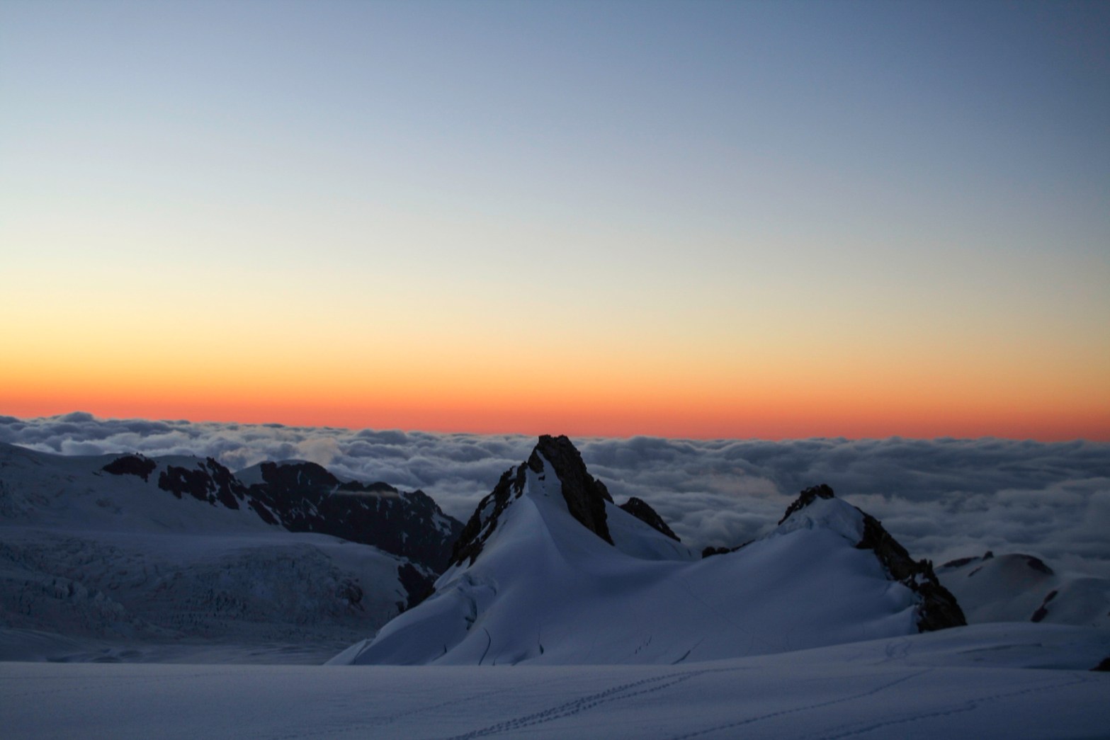
The late afternoon gave some different views again as the clouds started to come up from the valley and wisps seemed to float up from the glacier itself.
clouds wisp up the glacier
The next 2 days were a complete write off with the weather completely closed in around us so I took the opportunity to relax a bit and play cards with some of the others.
On the morning of our scheduled departure day the weather still had not improved so in the hopes it would get better, we packed our stuff ready to go and waited around while our guide communicated with the helicopter operators.
By early afternoon it was looking like we would be here for at least 1 more night and possibly 4 more looking at the forecast when we received a radio call from the chopper pilot saying he had found a hole in the clouds and would be here in 5min.
We quickly grabbed our gear and rushed outside to meet the chopper.
Flying back out all we could see was cloud below us but sure enough the pilot found the same hole in the clouds, descended through it and brought us back to the landing area safely. No sooner than we had landed and the hole in the clouds closed up again.
I had an awesome time on this trip and learned a lot including that I need to be fitter next time I try something like this.
Craig’s Hut is a beautiful place and is a easy weekend or possibly day trip from Melbourne. This trip I did was a camping and relaxing weekend with a couple of mates.
The weather for the weekend turned out to be perfect, no clouds, light wind and being the middle of May, cool temperatures. There are a number of ways to get to craigs hut, the easiest and the way I took with the camper trailer in tow is via the Mt Sterling rd then onto the circuit rd and then up Clear Hills track. Only Clear Hills track is really 4wd and not a particularly difficult track where low range was used mainly due to the steepness and the load on the 4wd with the trailer attached.
The main campground is about 200m from Craig’s Hut and is big enough for large groups or a number of small groups. On the Saturday night there was 3 separate groups in there, one had 10 4wds and no one was on top of each other. There are also a few smaller campsites further along Clear Hills track if the main one is full or you don’t like to share.
Craig’s Hut is not a traditional alpine hut, but was built for the movie The man from snowy river. It is positioned on a ridge with an amazing view (so great for a movie). The Hut was built in 1982 for the movie and rebuilt in 2006 after being destroyed by bushfire.
Beyond enjoying the views here, there is a lot to explore in the area. 4wding, hiking photography are all very popular in this area however the 4wd tracks are closed during winter as they become covered in snow and dangerous to try and drive. You are still able to access the area on foot or by skis with the cross country resort of Mt Sterling close by.
A lot of people stop at Craig’s Hut for 1 night as part of exploring the area but you could just as easily use it as a base camp an do day trips (i’ll probably do this next trip).
If you haven’t been to Craig’s Hut I highly recommend it and check out more of the beautiful High Country while you are there.


