Leaving Carnarvon Gorge, we headed to Emerald for a couple of nights to restock and see a few sights. When we arrived in Emerald we had to scrub the roof of the camper and wash the car to get the bat poo off before it caused any damage.
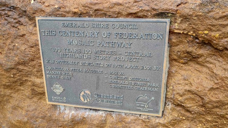
While there we checked out the giant Van Gogh painting in the park, got some supplies and cooked up some pre prepared meals that we vacuum seal and freeze. We also did a short 1/2 day trip out to Sapphire and had a bit of a look around there.
Monday 17th October we were off again, this time to longreach for 4 nights. We actually stayed at the caravan park in Ilfracombe which is 25km east of longreach as there was quite a bit of rain forecast and the council campground in Longreach was known to turn into a mud pit when it rained (not ideal).
It is a great little park next door to the Wellshot hotel and has a great little kamp kitchen and clean large toilets and showers.
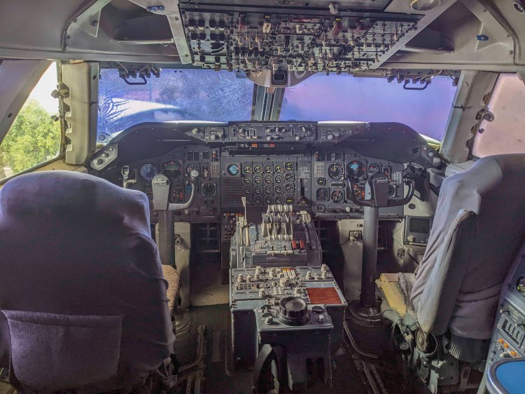
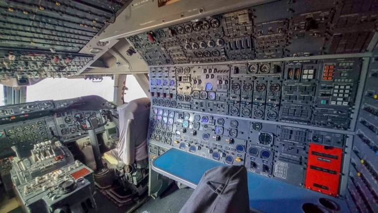
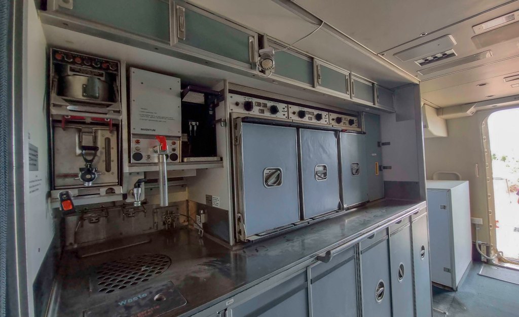
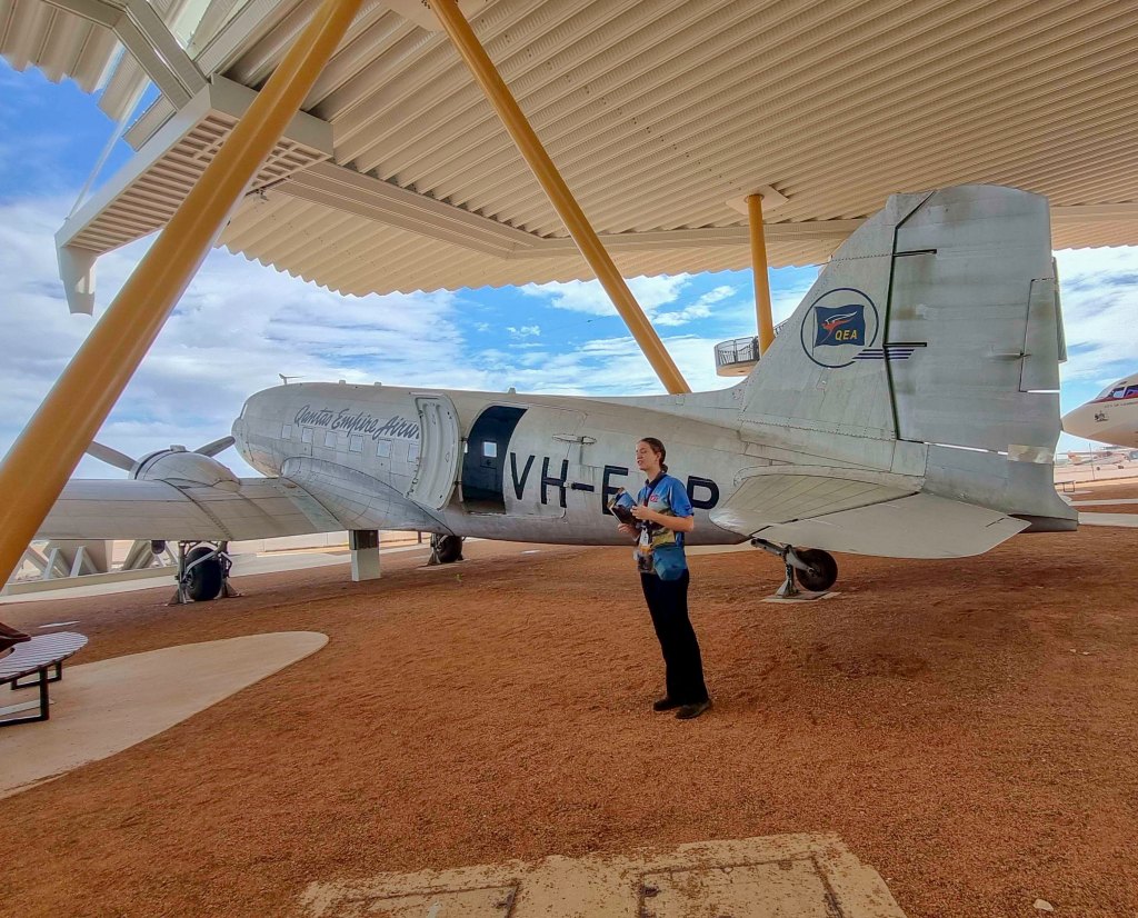
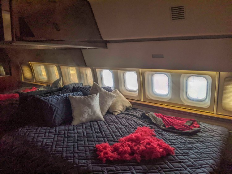
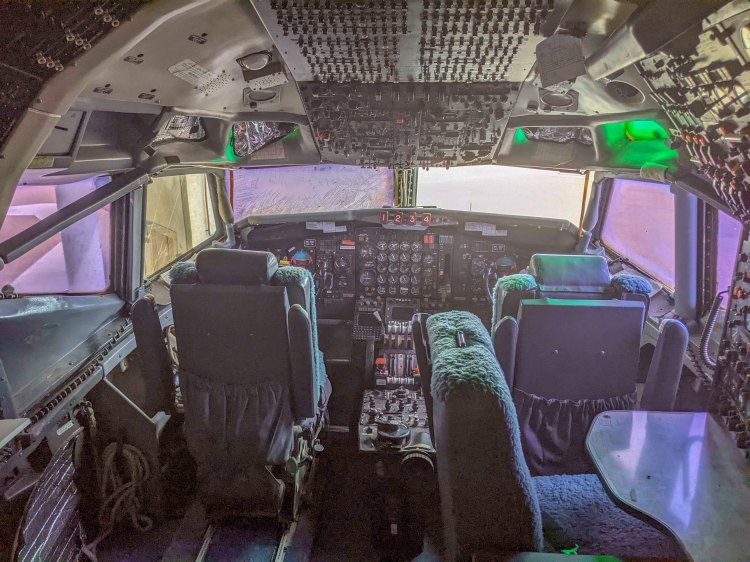
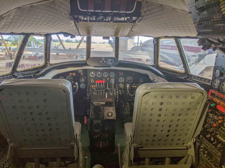
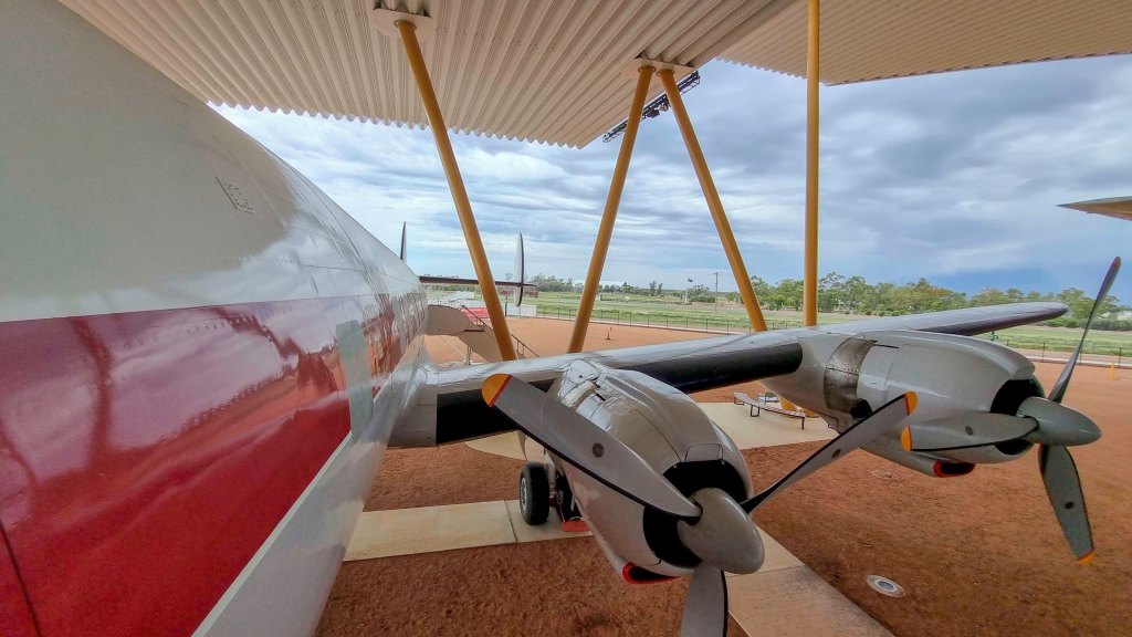
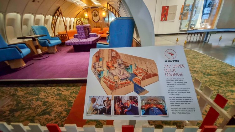
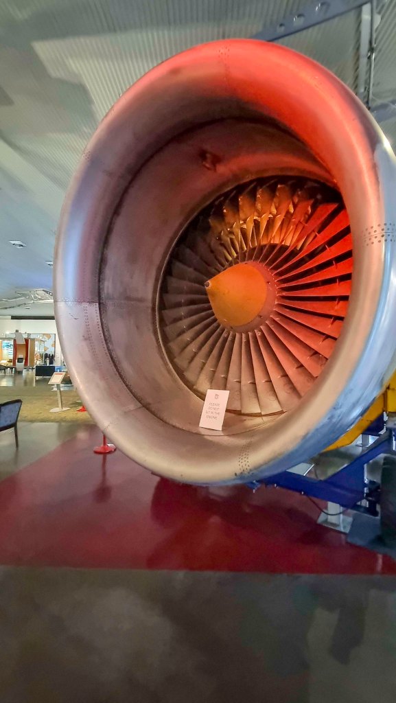
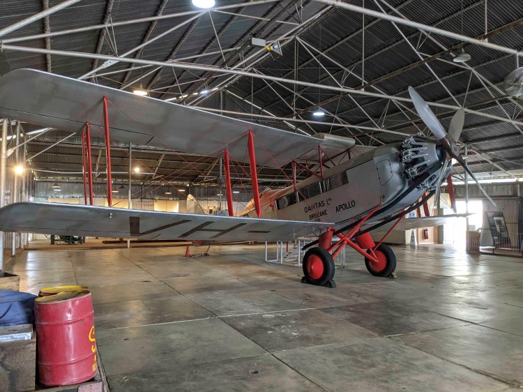
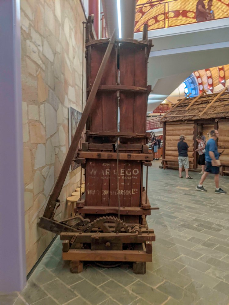
Tuesday we went to the Qantas founders museum which was definitely a highlight for us. We did the guided tour which we went through 4 different aircraft, a 747, 707, DC3 and a Super Constellation. The 747 showed how they were set up for economy, business and 1st class in the early years of the 747. You can check out the upstairs, cockpit and galleys. The DC3 is actually a converted C47 which is the military version. The main difference between the 2 types is the C47 has a much larger door in the back.
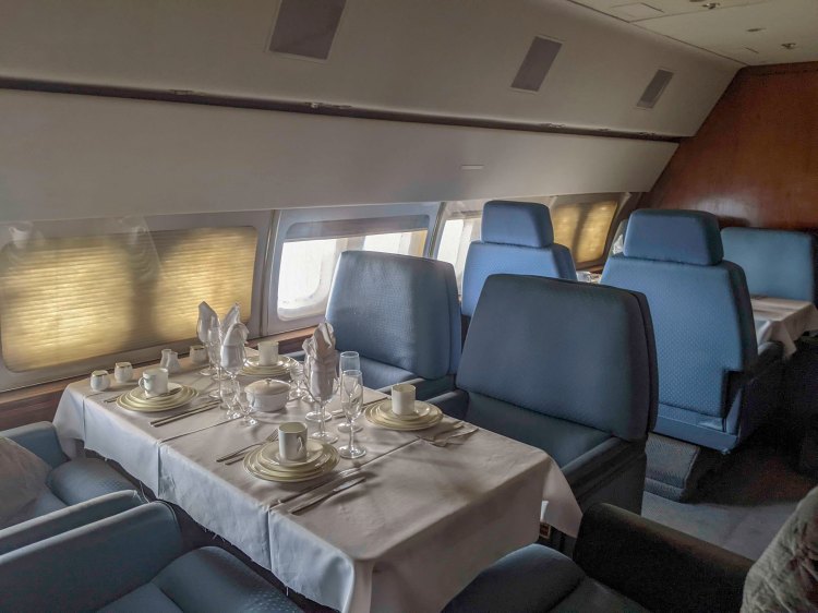
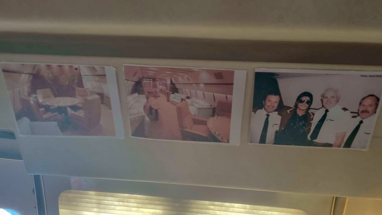
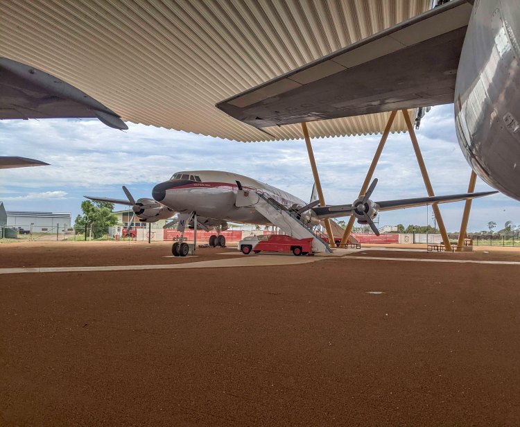
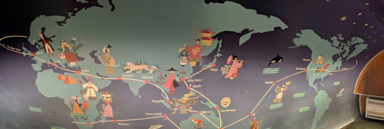
The Super Constellation has a great display all along the inside, showing the routes they flew all over the world and the 707 was actually setup by a previous owner as a high end private aircraft aimed at being sold to arab nations. This was however unsuccessful and it was used briefly as a charter plane to people like the Jackson 5. It was almost bought by Michael Jackson until the noise limitations on aircraft changed making the 707 not usable.
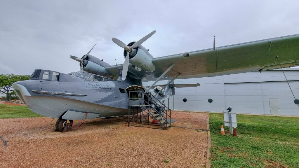
After the tour we went through the museum. There is so much great information and displays there and the kids loved the simulator.
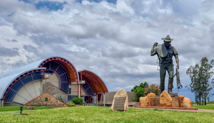
The next morning it was into Longreach again and this time to the Stockmans Hall of Fame. This is another amazing experience full of history and unique stories. The display has been changed a lot in the last few years. Now, each person gets an Ipod with headphones and as you walk into each section, the ipod plays an intro to that section. There is also lots of additional audio clips you can select for each section that relate to the displays in that section. The kids also get an Ipod and headphone but they have a different app that allows them to listen to clues for each area and find different items on display. When they find it, they hold the camera of the Ipod up and if correct they get a digital sticker on the ipod. The aim of course is to collect all the stickers.
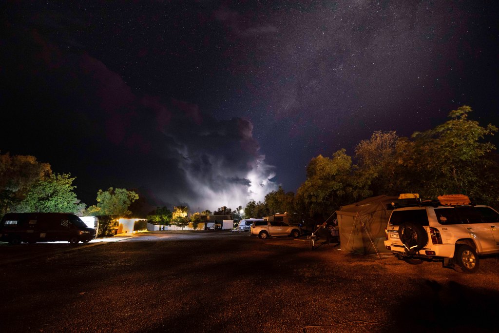
Thursday was a quieter day. Had to have the car looked at again as it appears the last mechanic didn’t do a very good job as one of the parts when put back on, was not done correctly and was leaking. Organised to get it repaired next week and thankfully we are still able to use the car until then. In the afternoon we went to the pool in Ilfracombe to cool off. We also got a great light show from a storm to the south of us in the evening.
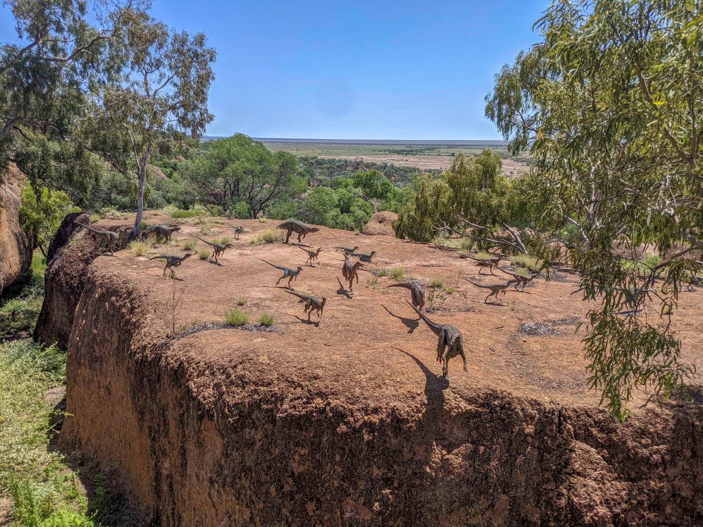
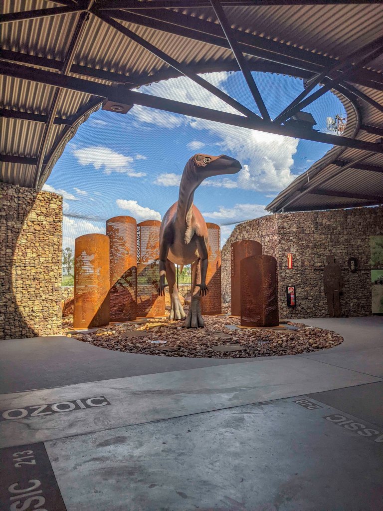
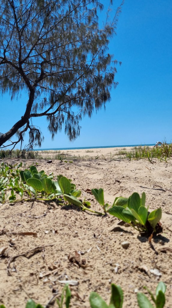
Friday 21st October we moved on to winton to see the dinosaurs. Here we camped at Long waterhole which is a free camp just outside Winton. A nice spot right by a waterhole with no facilities so we set up our shower and toilet at camp. We found a nice spot near some trees so we had good shade in the afternoons. The only bad point is that we did have to keep an eye out for some of the smaller locals, we found a couple of redbacks and a huntsman in the shower one morning.
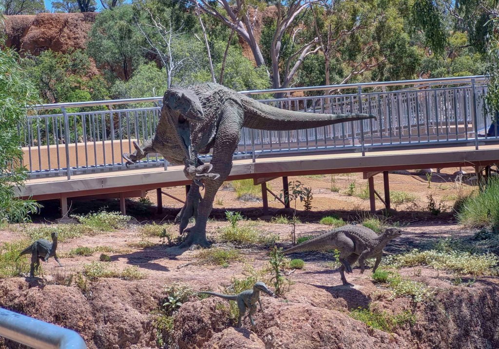
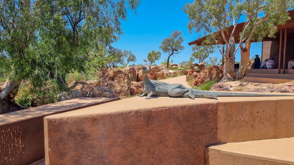
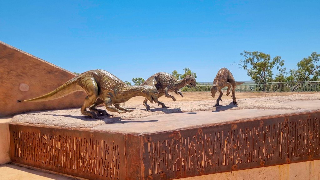
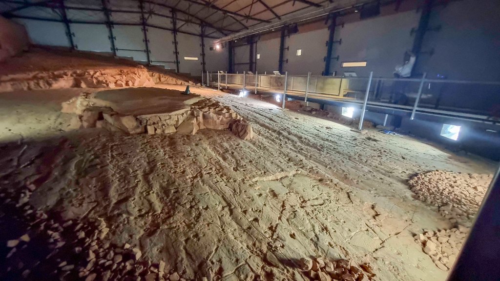
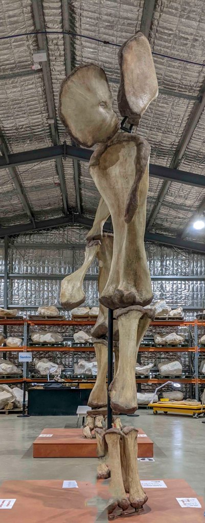
Saturday we did the Age of the Dinosaurs museum. We did the full tour encompassing the canyon walk and footprints area, the collection room and the fossil prep laboratory.
The Canyon has information on the different types of dinosaurs found in the area and statues of them in the canyon. The footprints are an area where you can see Sauropod prints as well as other smaller dinosaurs.
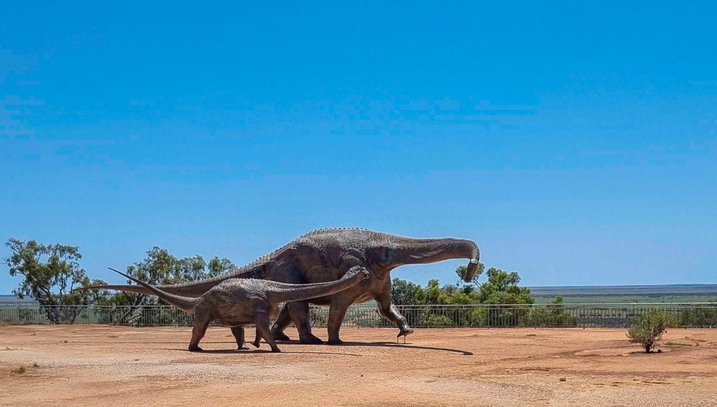
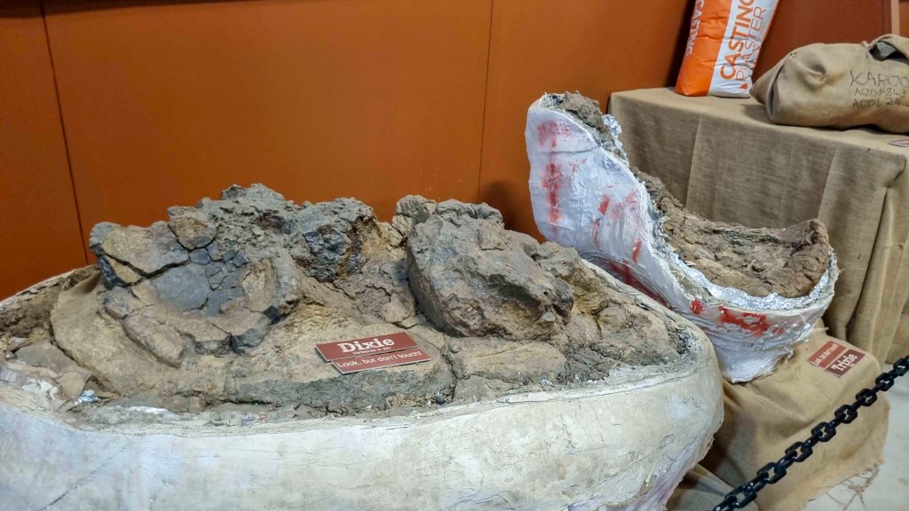
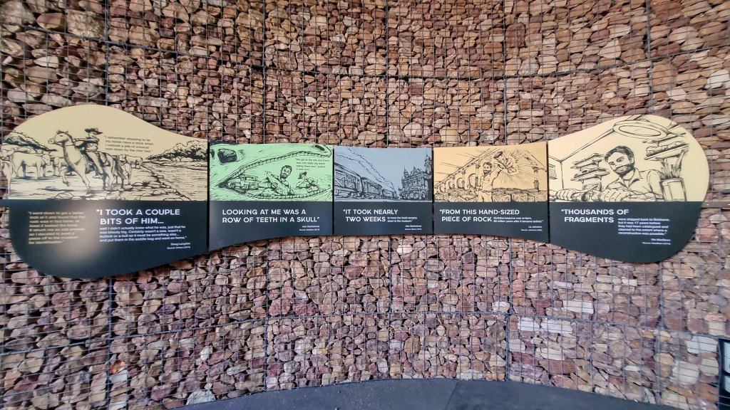
The collection room has an awesome display of both Banjo and Matilda’s bones as well as a video on how they were found. Matilda or Diamantinasaurus Matildaewas a very large sauropod that was up to 30m long and Banjo was a Australovenator wintonensis or very big Raptor far bigger than a velociraptor.
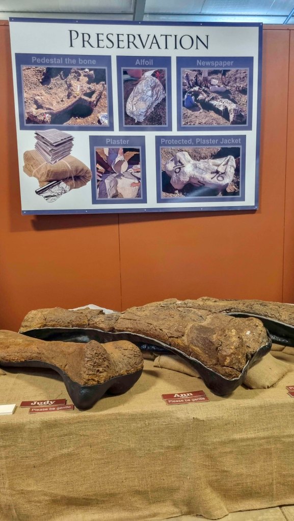
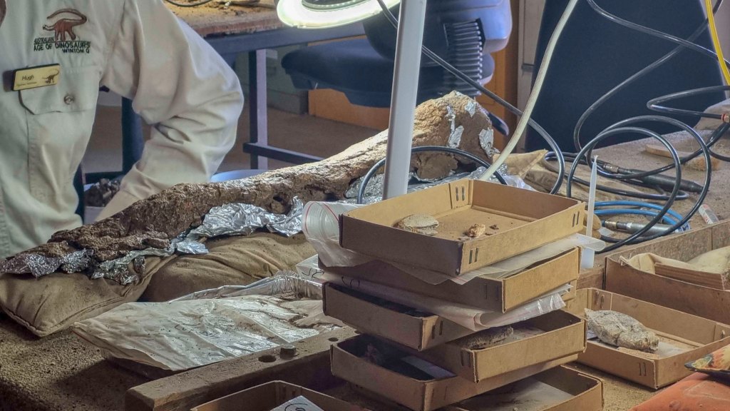
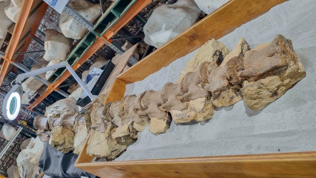
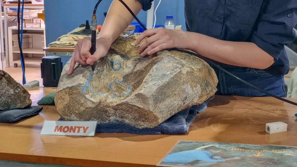
The Prep lab as the name suggested is where they prepare the bones that are recovered from the dig sites. It was really interesting to see people actually working on the fossils and how they use the tiny tools to slowly dig away the dirt and rock around the bones.
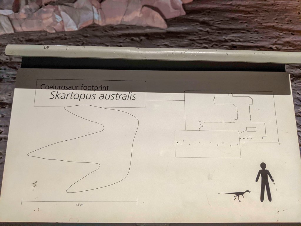
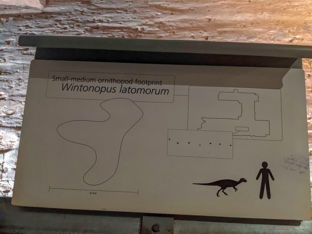
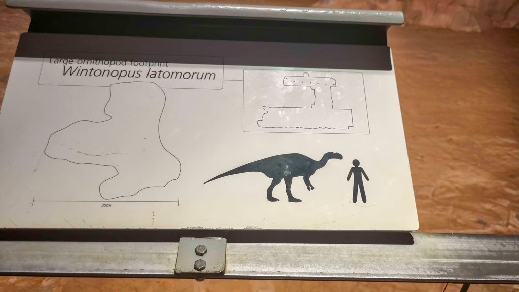
Sunday there were more fossils to see, this time to Lark Quarry which is 110km south of Winton. Lark Quarry houses the world’s largest collection of dinosaur prints in one place with over 3000 prints. It is called a stampede as that’s exactly what happened. There were lots of smaller dinosaurs of 2 types all hanging around a waterhole, one was the Skartopus australis which is a small meat eating Theropod and the other, the Wintonopus latomorum which is a slightly bigger plant eating Ornithopod. A large Raptor Dinosaur like Banjo came through this area causing all the other smaller ones to stampede. You can see where the raptor has come through and even where it started to run after the smaller ones as well as the thousands of small prints from the others trying to escape. This site has been really well preserved as they have built a building around the stampede site to protect it as well as make it available for everyone to visit.
That night we had dinner at the North Gregory Hotel. Very yummy large meals.
Monday 24th October, it was time to pack up again and head towards Muttaburra but 1st we stopped at the Waltzing Matilda centre which shows the history of Banjo Patterson, the famous poem and the Winton. This is a really good exhibit with loads of information on life at the turn of the 20th century, a video on how the poem has woven its way into our culture as well as some equipment from a steam train to old farming and medical equipment from the same era. There was even an iron lung.
We left Winton about lunch time and arrived in Muttaburra about 2.30pm. We had intended to camp there for a couple of nights however arriving at the campgrounds we decided to have a quick look at the Muttaburrasaurus and go straight back to Longreach. There is absolutely nothing wrong with the campgrounds which have a pay 2 stay 5 deal and nice clean toilets and showers (even had its own resident frog), but like a lot the area there is very little shade and at the time we were there it was 42 degrees and the ground was so hard we would not have gotten the pegs into the ground for the awning.
The Muttaburrasaurus display is a small display but really well done and free. well worth the visit.
A bit over an hour back to Longreach and this time we stayed at the the Longreach tourist park as the car was going back to the mechanic on Thursday.
The park did not review well however we thought it was a good place. The sites and road ways were all compacted redish stone and dirt, good clean facilities and even a pool (although this was starting to look a little green).
Tuesday was a quiet day just relaxing around camp and had a swim. So far on our trip we have done approximately 5600km.
Wednesday was another relaxing day until a massive storm came through at around 9pm and we had to stand outside and hold the awning down so that it did not take off over the camper. The kids were a bit scared but we all came through just fine and no damage.
Thursday morning we took the car to be fixed again so just hung around camp again. now it’s starting to get boring and we want to get going again.
We got the car back about 10am on friday morning and while I walked into town to pick it up and get some supplies, the rest of the family packed the camper and we headed off at lunch time for Quilpie.
A bigger drive today and we arrived in Quilpie at 6.20pm, quickly set up and had dinner at the bowls club. Go have dinner at this club if you are in Quilpie, it’s a small place but has great huge meals, cheap drinks and a kids playroom. We had Chicken Parmi and salmon with a creamy caper sauce while the kids had fish and chips and pasta.
Saturday 29th October it was off to Eromanga to see Cooper, Australia’s largest dinosaur at the Natural history museum.
Cooper or Australotitan cooperensis is a Titanosaur and a 4 legged plant eating sauropod. The Tour includes a video on the area and the dinosaur finds and a tour through the research area and lab where they prepare the fossils.
They have decades of work ahead of them to prepare all the fossils just in the ones they have already dug up and stored here. There are bones from a number of different dinosaurs and a huge replica of coopers legs to get an idea of the size of him.
This region of central western QLD is an amazing area, full of so many great attractions and things to do and see. From Longreach and the Qantas museum and stockman’s hall of fame, to Winton and the dinosaur centres and the waltzing matilda centre and Quilpie and eromanga with the natural history museum. It is we worth visiting the area and spending time checking them all out. There is so much more out there too that we didn’t get to for those who have time like north to Richmond and Hughenden for more dinosaur history and many national parks to explore.
All these attractions do cost money and yes it does add up but it has been an experience that we will remember forever for us and the kids and worth every cent.
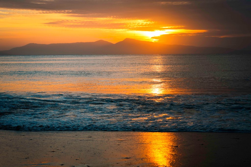
Sunday was a bit quieter and we went fossicking for opals and founds a number of thin lines of opal in the small rocks before heading to the local pool for a swim in the afternoon and up to a nearby lookout for sunset.
Sunset from Baldy Rock, Quilpie
Monday 31th October we packed and headed east towards charleville. Our original plan was to stay a couple of nights in charleville and do a night tour at the cosmos centre, however the forecast was for storms monday night and cloudy tuesday night as well so wouldn’t see much on a star tour. Because of this we decided to stop at the cosmos centre and check out the other displays there which were really great and very informative, before stopping in the little town of Wallumbilla and staying at the showgrounds for the night. Thankfully we were able to find an area that was solid and grassy as the expected storms arrived about 7pm and lasted on and off most of the night.
Tuesday morning we grabbed breakfast from the local store and made an early start on our way back to Hervey bay. While the ground where we camped was very wet, at least it was still solid so no problems getting out again.
After a quick stop in Wondai for lunch, we arrived in Hervey Bay just after 3pm.
This concludes part 3 of our big adventure. From here we will start heading south through NSW with lots of hikes and national parks to explore.
As mentioned in part 1, we ended up in Gladstone with a broken car and we ended up being there for a week. Even though we were on foot for the week we still managed to see a few things as well as do some planning on places we want to see as we continue our travels.
The show grounds in Gladstone are a nice place to camp, cheaper than the caravan parks with all the facilities. From there it was an easy walk to the shops for supplies and a few restaurants. A bit further away was the waterfront area which has a great park area with a playground and water park for the kids. Further along the park is the HMAS Gladstone, an outdoor cinema and maritime museum.
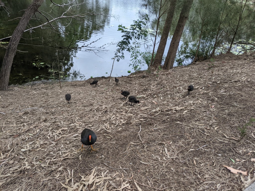
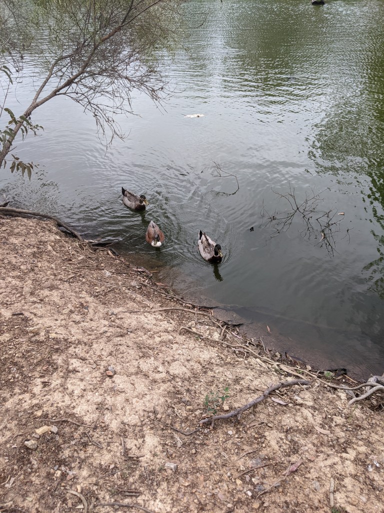
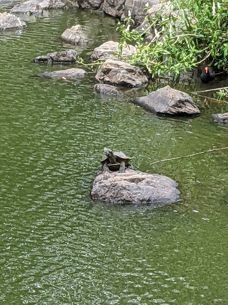
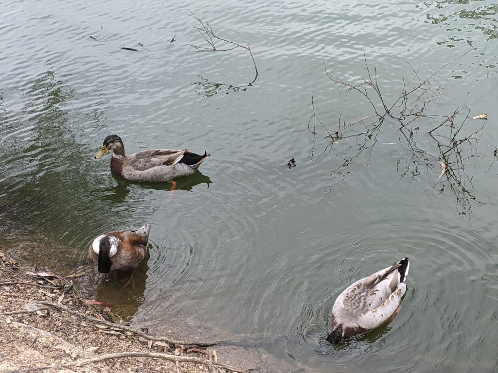
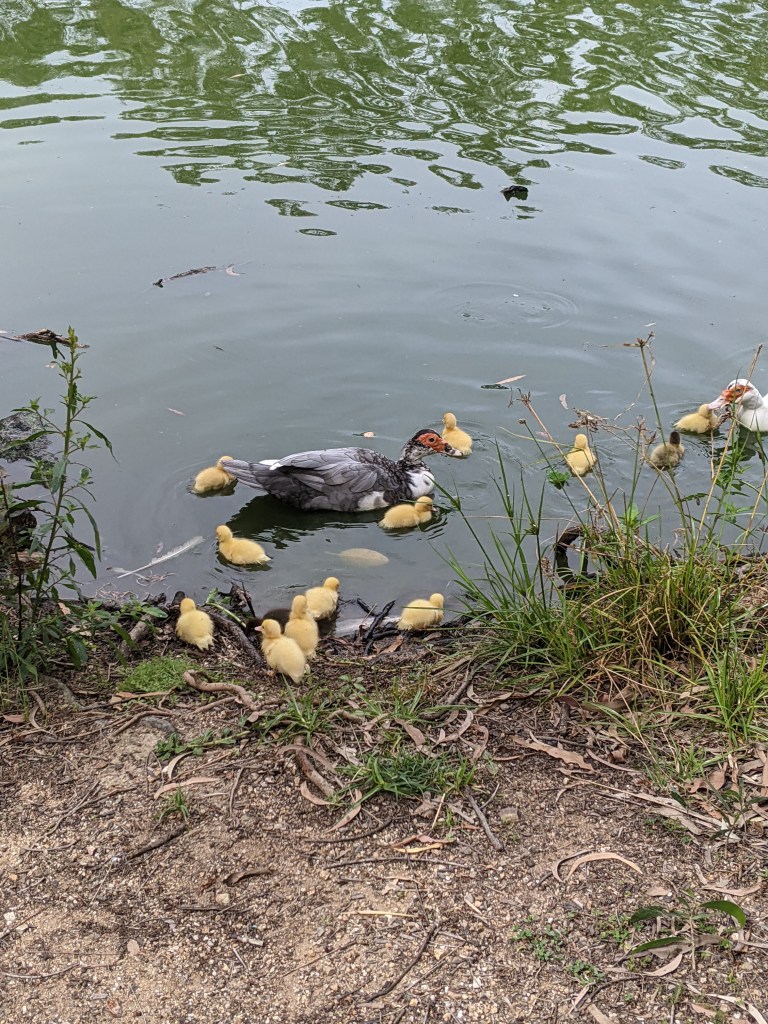
Another spot nearby the showgrounds was a park with a small lake. The kids loved the lake which had heaps of turtles and ducks.
turtles coming to see if we had food
Finally getting our car back on Friday 7 October we hooked up the camper and headed to the small town of Bluff where we stayed for 4 nights. From there we spent 2 days exploring Blackdown Tablelands and a day checking out the coal centre and museum in Blackwater.
The pub in Bluff is a great place to camp. $10 a night with toilets and showers, great meals and even free use of a washing machine.
Bluff Hotel, camping out the back
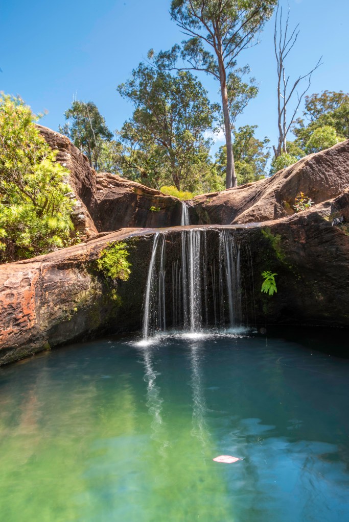
Blackdown Tablelands is breathtaking, waterfalls, rockpools and lookouts galore.
On the 1st day there we had a quick look through the campground which looked pretty empty even though it showed as booked out on the parks website and then on to Gudda Gumoo gorge where we did a 4km return hike to the rock pools above the falls. Cool refreshing water and a couple of small but deep rock pools to have a dip in. The water is crystal clear and a bit of a shock when you first get in but so refreshing. There is even a very short tunnel between two of the holes you can swim through. We relaxed there for a while and the boys played them headed back to the car to make lunch.
DCIM100GOPROGOPR0262.JPG
After lunch we did the 4wd track around the western side of the plateau which was a nice easy drive but definitely for 4wd only as there are a few rougher climbs. On the drive around we saw lots of different sandstone formations and one of the spectacular lookouts.
Returning to the main Rd heading out, we stopped at yaddamen dhina lookout for some more photos before heading back to camp.
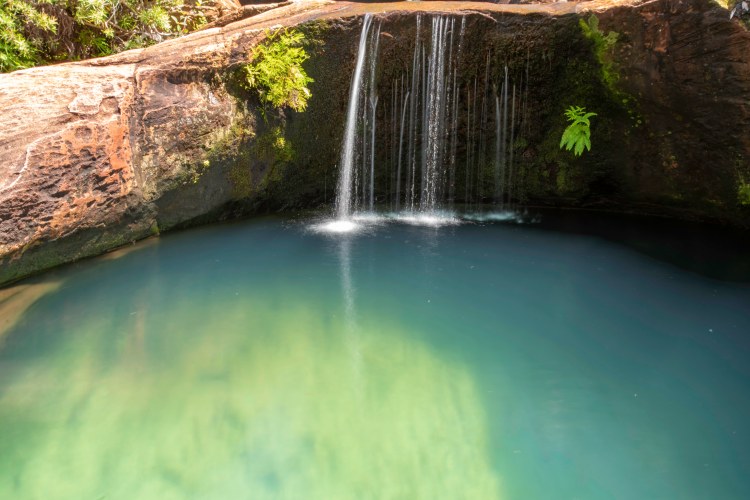
The next morning we headed back to Blackdown Tablelands early and back to Gudda Gumoo gorge. This time to go down the 240 stairs to the base of the falls. We did not do this the day before as our 3 year-old was at his hiking limit already.
The falls, just like the rock pools the day before were beautiful and cool. A lovely big pool at the base of the falls to swim in. As we got there early we even had it to ourselves for a while anyway.
After a swim we made our way back to the car for lunch then back to camp for the afternoon and for me to to watch the end of the Bathurst 1000 on tv ( priorities!!!).
Our 3rd day staying in bluff we went to the coal centre and museum in Blackwater. A great facility with a nice cafe.
The museum was good with lots of great information and visual displays. We spent half the day there and grabbed lunch at the cafe before heading back to camp for a relaxing afternoon.
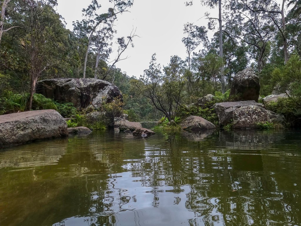
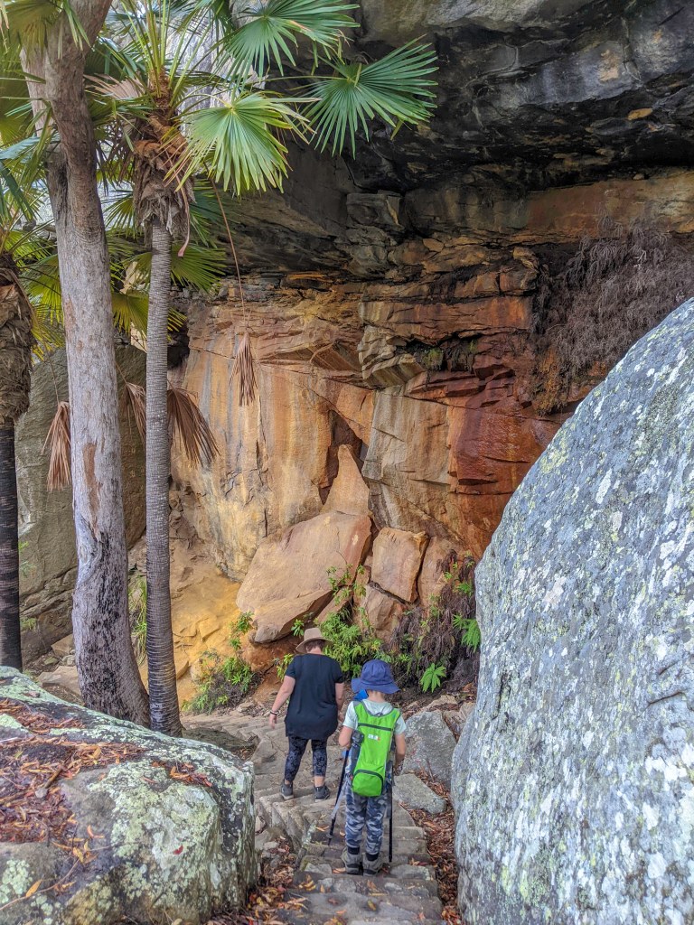
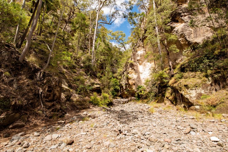
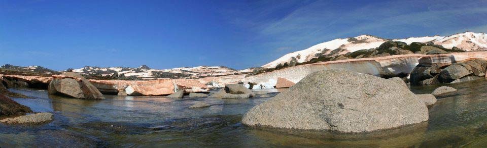
Tuesday morning it was time to pack up and head to the much anticipated Carnarvon gorge for 4 nights. Its about a 3 hour drive from Bluff to the gorge and we arrived at the caravan Park at about 1pm.
It is a great park although a bit pricey at $48a night for an unpowered site but there isn’t any other options close by so it’s a captive market for them. The facilities are nice and they have a video in the bar area each after about the walks and the gorge which is great for the new arrivals. During our stay we had echidnas wander past our camp and also saw a platypus in the creek bordering the caravan Park.
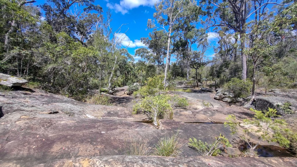
That 1st afternoon after setting up we headed to the national parks info centre and did the short nature trail which is about 1.5km and follows the creek down and back.
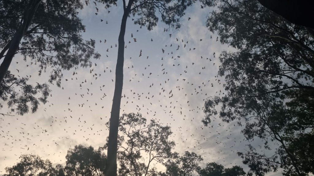
One unwelcome seasonal inhabitant of the area are the fruit bars by the millions. Thankfully they slept on the other side of the caravan Park to us but at dusk they all departed and at dawn returned. This did make for an awesome sight but the droppings on the car and camper not so welcome.
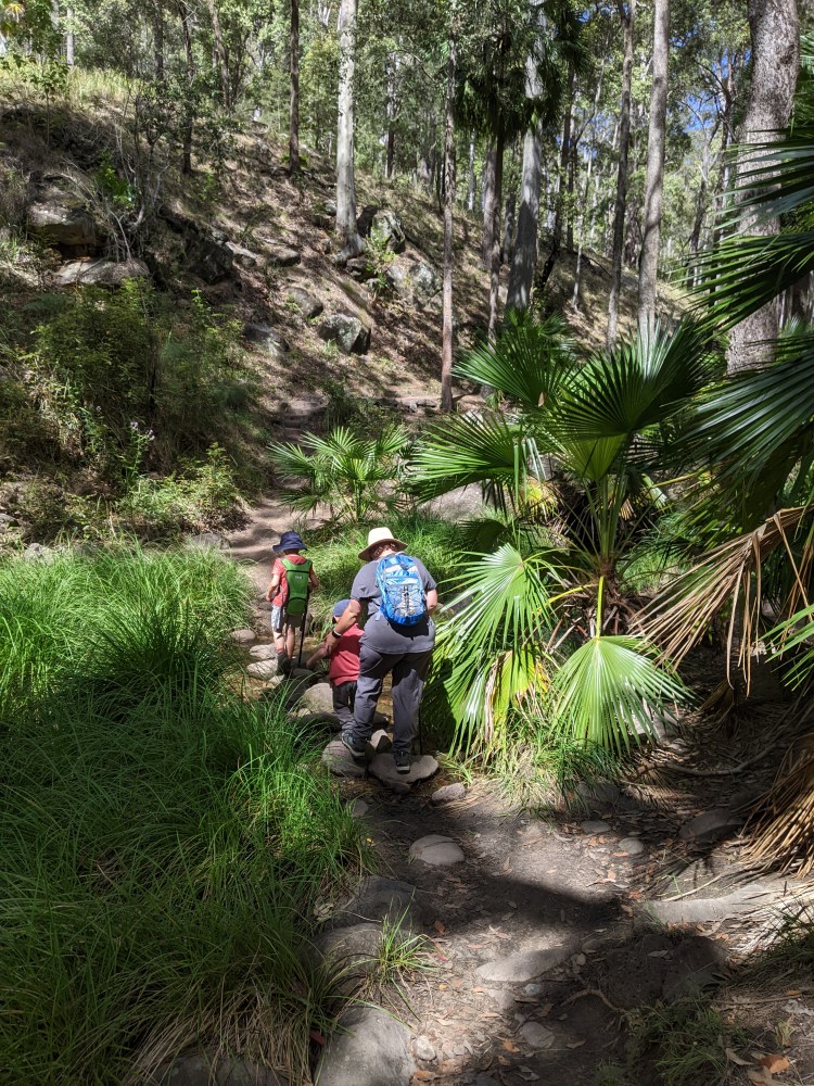
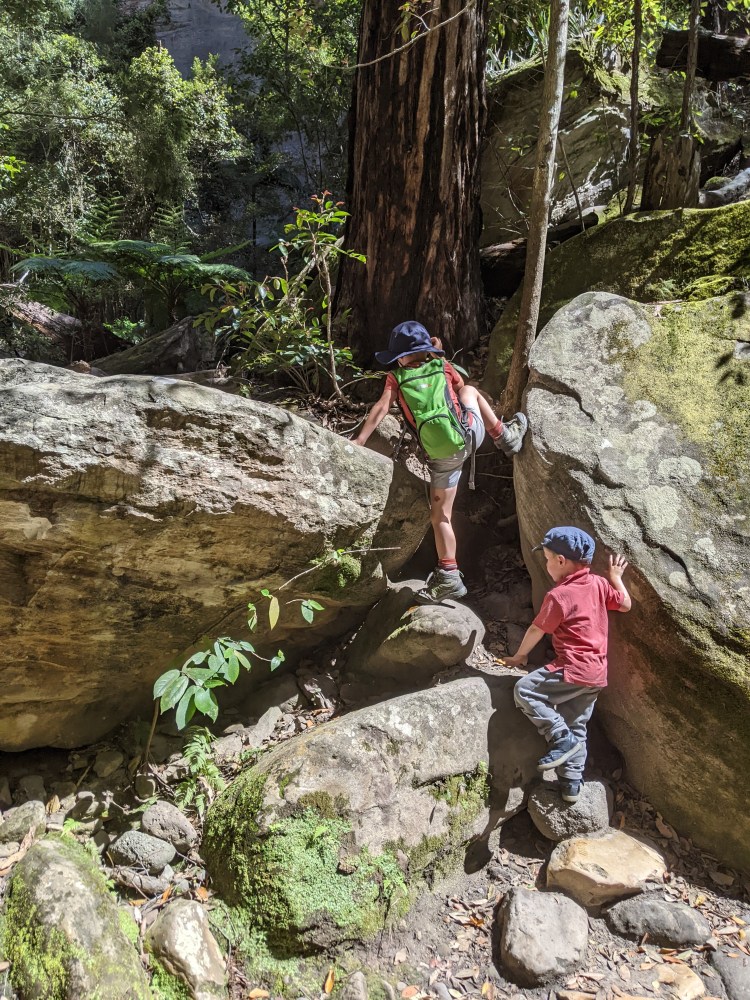
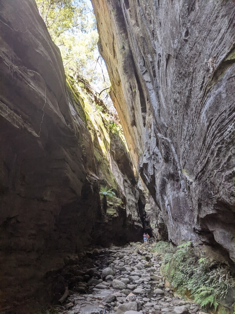
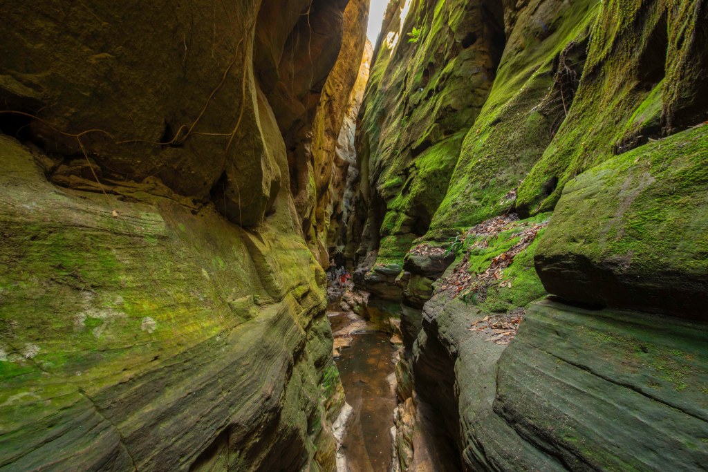
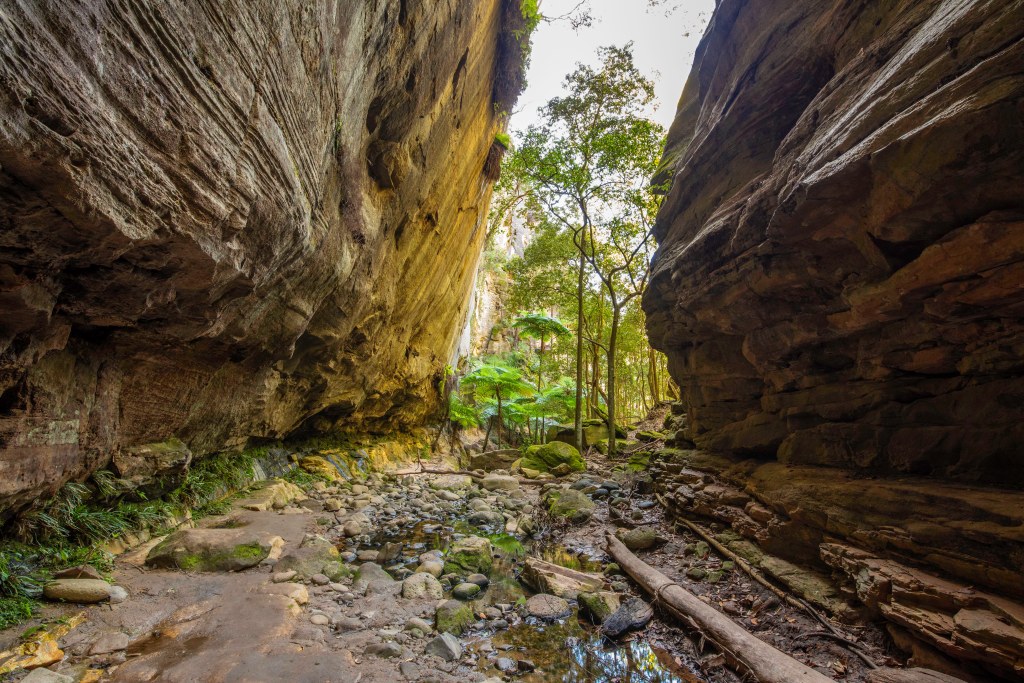
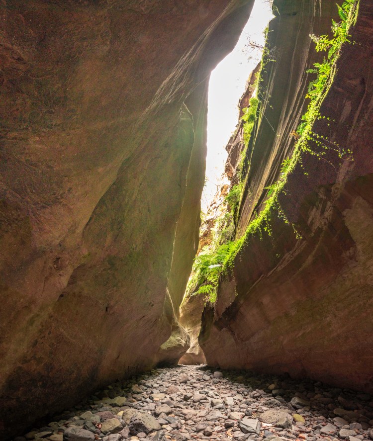
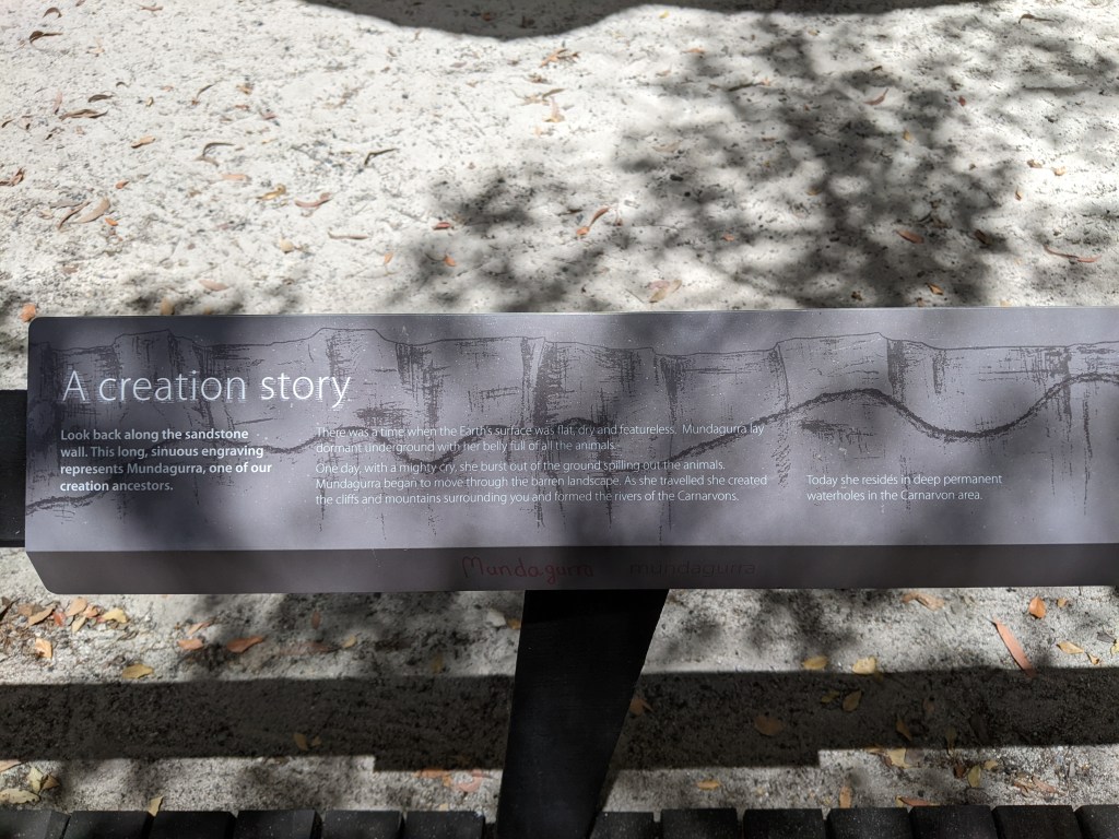
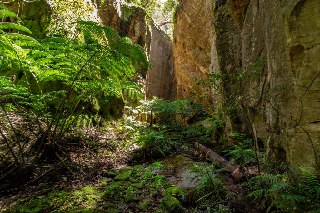
On Wednesday we all went off to do the Mickey creek gorge walk which also included warrumbah gorge. From the carpark we headed up to the intersection of the track where it forks to either gorge. We headed to warrumbah gorge 1st. Once you get to the sign saying end of formed track, keep going into the gorge. Warrumbah gorge is a beautiful, narrow gorge that leads up about 700m or so until the going got a bit to tricky for us to continue.
We then headed back to the intersection and took the other fork up to Mickey creek gorge. This one as far as we got is wider and involved more rock scrambling to get through.
After a rest and some snacks we slowly made our way back to the carpark. The kids did really well and in total we walked about 4-5km.
After lunch back at camp we made our way out again to do the short walk to the rock pool for a swim. The designated rock pool for swimming did not look inviting to us as it was surrounded with reeds and a bit stagnant. We followed the track a little further and came across a crossing with a deeper part next to it. We decided to dip our feet in there instead. On the way back we saw some turtles in the creek but no platypus yet.
swimming hole
Thursday we were up early as I was to do the main walk by myself while the rest of the family stayed behind and we would swap and she would do the walk on Friday as it is way to far for our young boys.
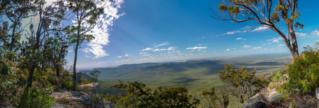
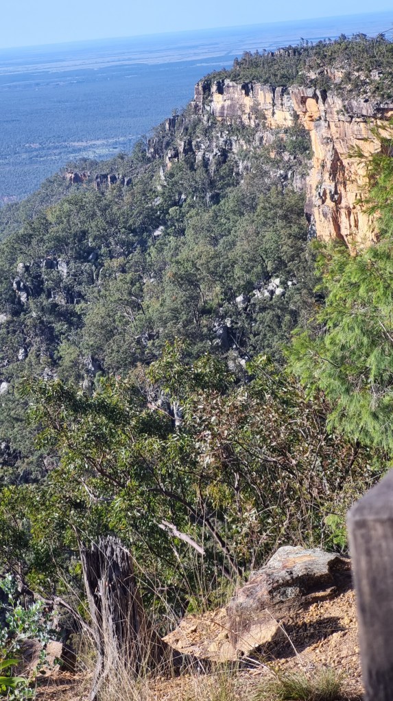
I started up the track at about 7.30am and quickly got into a comfortable rhythm plodding down the track in peace and quiet. As was recommended, I planned to head straight out as far as I planned to go and then do all the side walks into the individual gorges and sites on the way back. I wasn’t sure how far I would go as I hadn’t done much hiking in recent years and am very out of shape, however I arrived at the turn off to the art gallery by 9am feeling good apart from some slight soreness in my legs. This way 4.5km in and the choice was to stop here and to the 4 side areas on the way back or continue on another 4.5km to boowinda gorge and cathedral cave. It was still early and I was feeling good so off I went continuing on to the last two sites.
map of the walks
The further up the gorge you go the more frequent the creek crossings become. They were all fairly straightforward with solid stepping stones to cross them without getting wet feet.
I reached the entrance to boowinda gorge at around 1030am and headed into it before stopping for a nice break in the shade and something to eat.
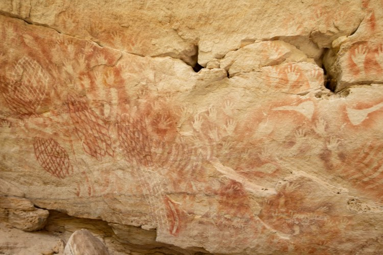
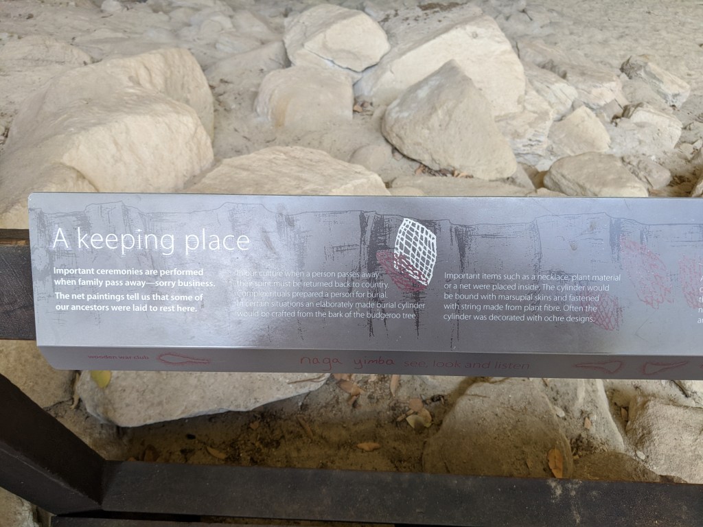
After a rest and taking some photos, I started back down the track and headed to the 1st stop on the way back which is cathedral cave. It is not a deep cave but ore a large overhang that was used as a meeting place for the local indigenous people. There is some beautiful rock art there however unfortunately in the past people have, in places also seen the need to scrape their names into the sandstone. I just don’t get why people feel the need to do this sort of thing. It damages the sacred locations and ruins it for the rest of us.
From there it was 4km back to the next side track to the art gallery, but on the way there is an awesome rock pool with clear views of the escarpment walls looking down from above. I stopped there for a rest and some photos of course.
By the time I reached the turn off to the art gallery I was starting to get a bit tired and my legs were definitely feeling it, but I had come this far and wanted to make the most of the day and see as much as possible so up I went. Another great spot with indigenous art in a sheltered overhang.
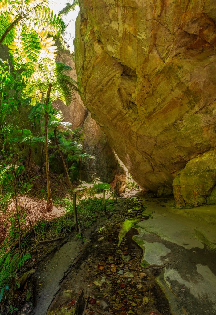
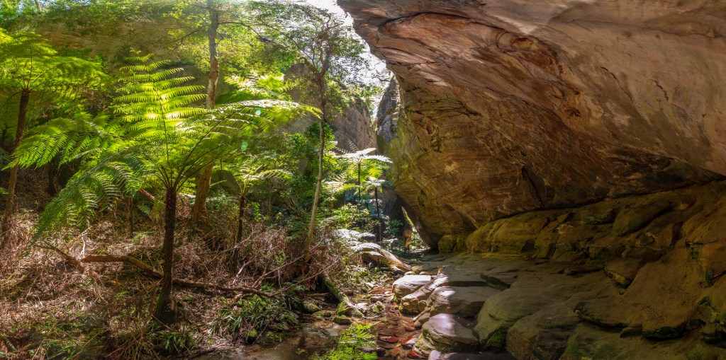
From there I headed back to the main track and only a short distance to the turn off to wards canyon. After already doing 16km or so, the steps up to wards canyon are a bit of a killer……. But buy is it worth it. This is an amazingly beautiful spot with a small creek running through it and luscious green ferns growing on the side. The rock in part overhangs enough to almost make a bit of a tunnel into the canyon. I spent a bit of time there enjoying the atmosphere and taking pictures before it was time to get moving again if I wanted to get to the other 2 sites before it got to late.
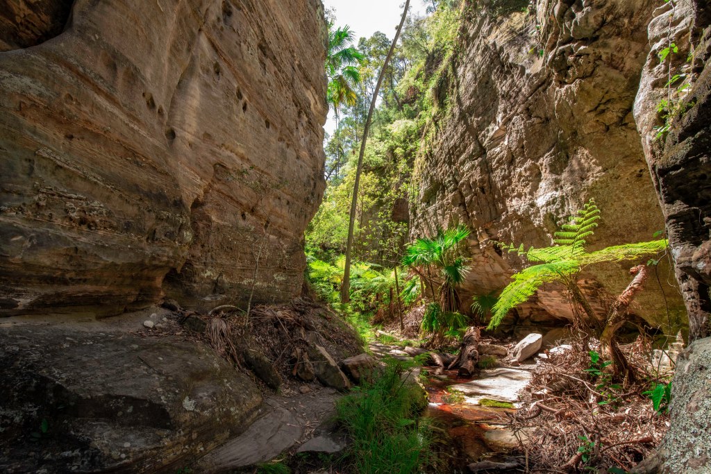
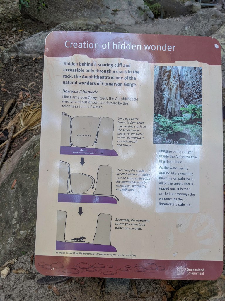
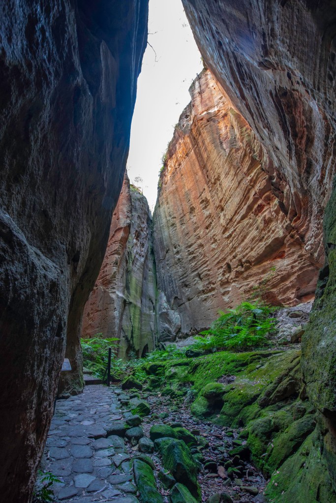
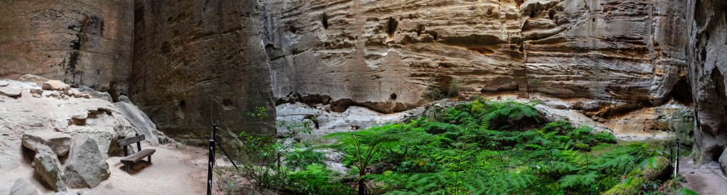
The next stop was the amphitheatre. Created by water slowly running down through cracks in the sandstone and washing it away from thre bottom to form the amphitheatre.
The entrance is a narrow gap in the rock well above the outside ground level, thankfully stairs have been put in. Passing through the narrow section where the water also drains it, I exited into a huge open top cavern or Amphitheatre. I was lucky enough to be the only one in there at the time and it was so peaceful, almost silent.
I sat there for a bit but probably shouldn’t have as my joints and muscles complained immensely when I got up again and headed off, back to the main track and then to the last stop of the moss garden.
Another magic place with as the name suggests, moss, as well as lots of ferns and other plants. At the end of the track is a boardwalk area right in front of a small waterfall. I quickly took a few pics and headed off again as there was a lot of mossies there.
There is one more side track on this walk which takes you up to the bluff above the start of the gorge walk but there was no way I was doing that with its 900 stairs at this stage of the day. Instead I kept heading back towards the start and finally arrived at 3.45pm absolutely wrecked. I ached from head to toe but it was well and truly worth it. In total the track including all the side bits to each of the locations was 24km.
This is such an amazing hike, everyone who enjoys the outdoors at all should come and do it at least once.
I definitely slept well that night.
Next morning we were up early again and I dropped the wife off to do the main walk and I stayed behind with the kids. She also did an amazing job and did the full 24km seeing all the sights. Back at camp us boys had fun riding the 4 wheel bikes around the park and played before having a campfire in the afternoon to cook a nice roast chicken and veggies for dinner.
Saturday morning it was time to pack again and head off to our next stop which would be Emerald.
Thats the end of part 2. Look for part 3 soon when we continue west to Emerald, Longreach and Winton
Over the Christmas / New Years period of 2019, we along with some good friends headed to Tasmania for a month to explore as much as we could in the time we had. Tasmania has so much to see and do for such a small place that you could easily spend 3 months there and not see everything, so we packed in as much as we could in the month.
waiting to board Spirit of Tasmania with the Queen Elizabeth docked opposite
To get to Tasmania we decided to take the day sailing on the Spirit of Tasmania ferry as it was cheaper than the night sail. The trip takes about 12 hours and having 2 young kids we chose to get a cabin anyway so we could have a rest and the kids could have a sleep when needed. Now I usually do not get seasick but as the ship travels north, south and the currents run west to east it always has a small roll throughout the trip which did make me and the wife feel a bit unwell. (thank god for the cabin to lay down). Flying would have been quicker but we were taking the 4wd and camper so boat is the only way to go.
Taking a car and trailer to Tassie is fairly expensive and if only going for a week or so may be to much for a lot of people but when there for a month and with more than half of our nights in free camps along with having our own 4wd to explore was well worth it to us. Vehicles are subsidised on the ferry but trailers are not so as a result it costs less to take 2 cars than 1 car and a camper trailer.
On arrival we and after being inspected to make sure we did not bring in any prohibited fruits or vegetables, we made the short drive to Latrobe Mersey river caravan park for the night where we met up with our friends who had arrived 2 weeks earlier.
The next morning we all headed off together for Liffey falls where we stayed for 2 nights. What a beautiful campsite. Free and right beside the small river. here we played, explored the river and did the 6km walk up to Liffey falls which is quite a challenge when you’re unfit and carrying a 12 month old on your back.
adventurous boy in camp Liffey falls campgroundsLiffey river
Leaving Liffey Falls we headed to Launceston for some grocery shopping. We also had to get a new Jack Pack (Jack is our youngest and the pack he sits in we call the Jack pack) as the old one broke on the way back from Liffey falls. Good quality backpacks like these are not cheap but a great investment if you have very young kids and want to still get out hiking. We settled on the MacPac one and have been very happy with it.
Liffey Falls
While in Launceston we stopped at Cataract gorge for lunch and so the kids could have a play. We also took the chairlift across the gorge which my older son really enjoyed.
After lunch and a play we departed Launceston for Scottsdale which was a very picturesque drive with a great lookout on top of the range. There is a free camp just on the eastern side of town which has toilets and coin operated showers and is a nice little spot but you do get a bit of noise from the main road.
We stayed here for 3 nights and did a couple of day trips out and back. The first one was to Ben lomond NP and of course we took the back way there through the forests. The highlight of the drive has to be Jacobs ladder. This is a section of the dirt road up to Ben Lomond NP ski area that zig zags back and forward up the rock face to the top of the plateau. It is an easy drive with the road in good condition but for those afraid of heights it could be very scary.
Jacobs Ladder Ben Lomond NP
The view from the top is spectacular from the rock formations to looking over the lower hills to the north. We had lunch and explored the ski area but being Chrismas time there was no snow around, only a few wallabies, before heading back down and back to our campsite. I imagine it would be a much trickier drive in winter with snow on the roads.
Wallabys at Ben Lomond ski area
On the way back we came across a wombat that had recently been hit and unfortunately killed by a car. We stopped to check her, and found she had a live baby in her pouch. I carefully cut the pouch to get the baby out and we took it back to camp with us before contacting the Local Wildlife rescue group. The kids named her Coco and the last time we heard about her she was healthy and doing well in care.
I used to be a Wildlife Carer, which gave me the experience to know where and how to cut to get the baby out safely. I would recommend, if you’re not sure what to do, call the Local Wildlife Rescue.
Coco the baby wombat
The next day we headed to Pyengana cheese factory and had some tastings and of course bought way to much cheese (as we tend to do) before travelling further down the road to St Columbia falls for some lunch and a walk down to the falls. Its a short 400m walk through the ferns to the falls to a rocky narrow waterfall and a narrow creek.
St Columbia Falls
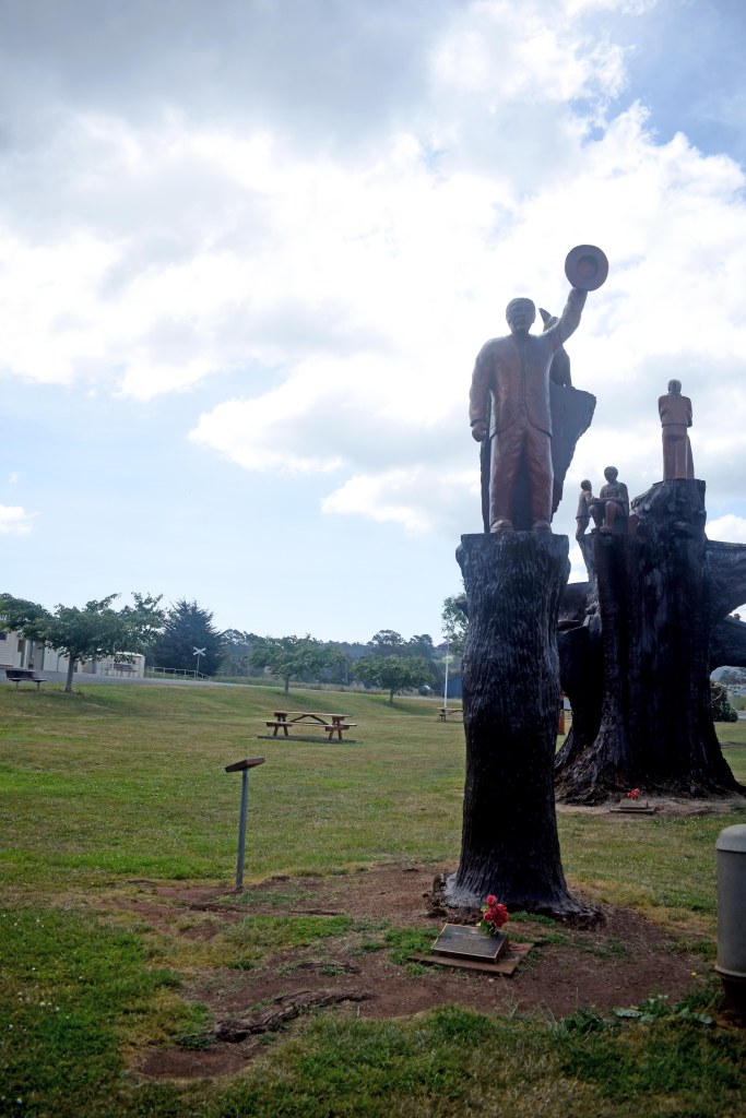
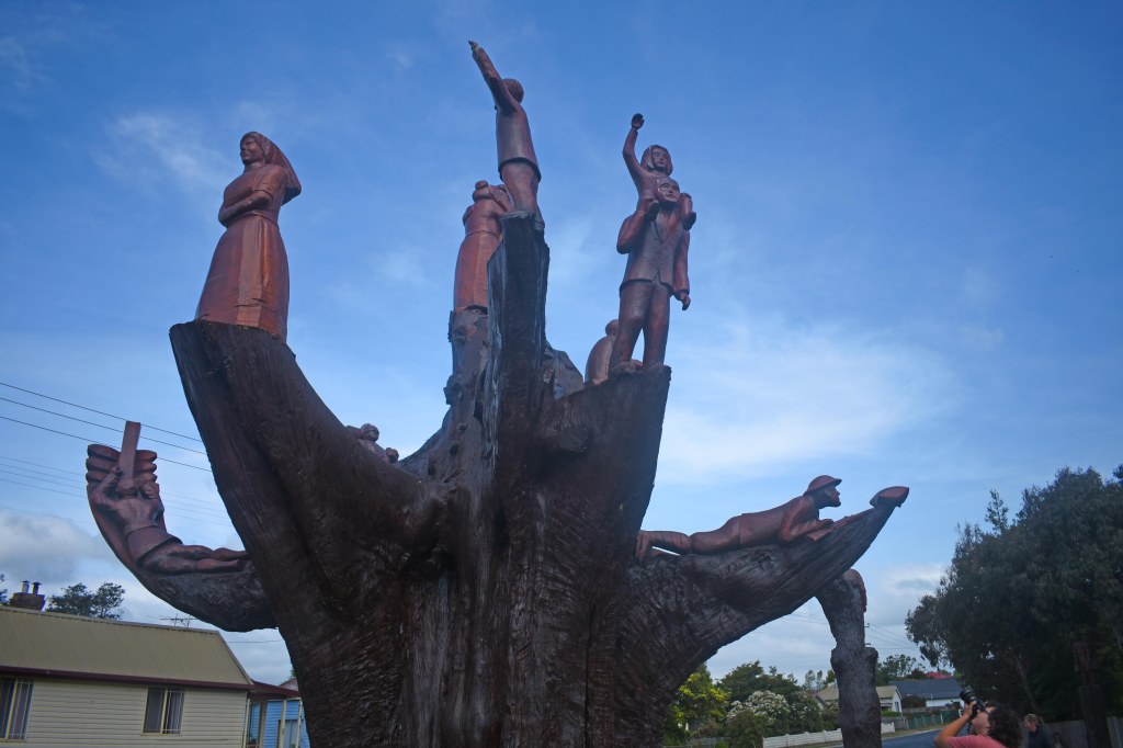
On the way back to camp we headed through the St Columbia state forest to ledgerwood to see the tree carvings that are memorials to the ANZACs.
Leaving Scottsdale we headed back to Launceston to have the brakes on the trailer looked at as they were squealing a bit when they warmed up. Turned out to be a dodgy batch from the supplier but a machining of the drums fixed the issue.
While in Launceston we checked out the city park and saw the monkeys and the kids had a play on the train.
From there we headed to St Helens and camped at Grants Lagoon near the Bay of fires for the night.
In the morning we headed off to see the Bay of Fires and take the obligatory photos then checked out the shop in the bush. It is an interesting place with all sorts of antiques.
The Bay of fires aptly named from the red on the rocks, while not giving us its best due to cloudy weather was still an impressive place. From there we checked out Bicheno for lunch and the blow hole there which was pretty cool.
After exploring Bicheno we headed to Swansea to camp at the caravan park for a couple of nights.
Sunday morning after an early rise for sunrise we relaxed around camp for the morning (needed after a busy week or so) then headed out about lunch time to check out the local wineries.
Sunrise from Swansea
We went to Gala, Devils Corner & Gala Knowe wineries and sampled the goods (as you do) then to the green frog cafe for ice cream which was a big hit with the kids. It was a quick dinner and bed after that before a big day the next day.
Monday morning it was up early to head to Freycinet National park with the intentions to do the walk to Wine Glass bay. When we arrived however we found out from the rangers that there was already over 300 people of the track so we decided we didn’t want to be apart of that crowded mess and changed our plans to do the lighthouse walk instead which still gave us great view including over to wine glass bay. It was also much shorter which worked for me carrying a toddler in a backpack.
We spent a bit of time up at the lighthouse taking pictures and relaxing before bundling back into the cars and heading to Mole Creek where we were staying for 4 nights over Christmas.
View from the Lighthouse
Mole Creek Caravan park…. Wow This place is awesome!!!
It is a small park so nice and quiet. We were camped right on the edge of the creek where we could splash around or look for the platypus or as some did, build a dam with the stone so we has the soothing sounds of water spilling over the dam all night. It is just one of those special places you find where the simplicity makes it perfect.
The 1st night there we went to the pub for dinner, the food was great and reasonably priced. We all just crashed in bed after that as it had been a big day.
Tuesday morning (christmas eve), we spent the morning doing much needed chores like clothes washing and such before going to visit some of the nearby caves. We took turns to go on a tour of the caves as we could not take the big backpack with the little one through the tight spaces, so Belinda went 1st into King Solomons cave with our oldest and then I went into Marapooka cave with Troy also. Marapooka cave has lots of glow worms and a small river running through it which was very pretty. Some last minute food shopping on the way back to camp in preparation for Christmas day.
25th December and a very Merry christmas at camp. We had pancakes for breakfast after unwrapping the presents and lots of running around the camp. Then a lovely lunch of ham and salads. It was a lovely warm day so the kids played in the creek all afternoon and the adults relaxed and we then had a cheese platter for tea, a brilliant day all around. It has been great travelling with our good friends on this trip making these special times even more memorable.
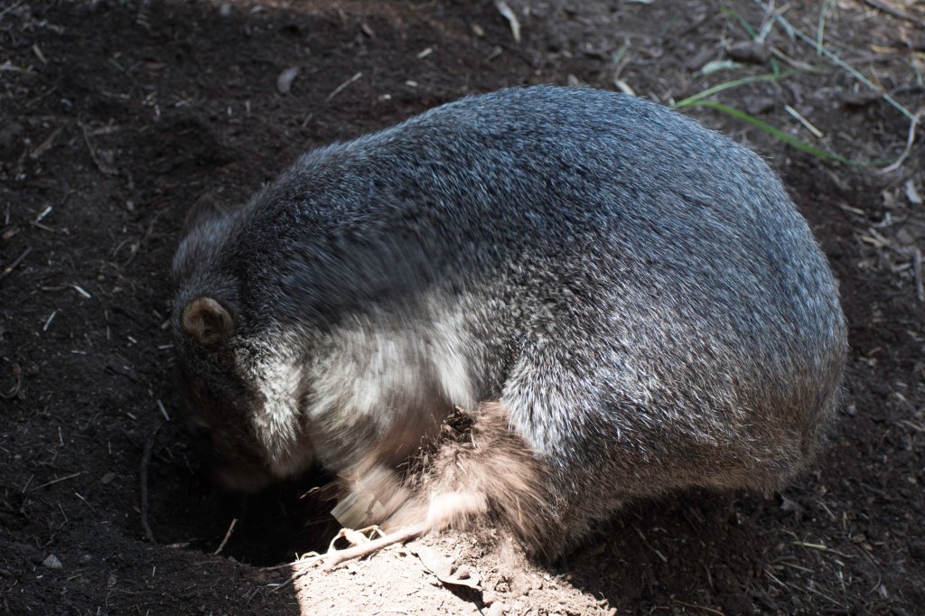
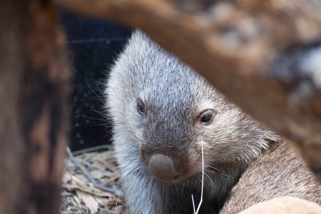
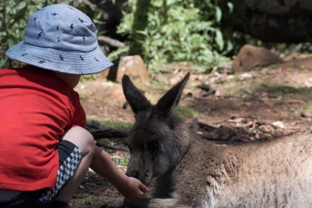
Boxing day we Headed to Turwanna wildlife sanctuary and saw lots of native wildlife including Wombats, echidna, Kangaroos, wallabies, potoroo’s, and of course Tassie Devils. Both the boys got to pat one of the wombats which was the highlight of their day.
Later in the afternoon we did a walk up to Alum Cliffs lookout, a fairly strenuous walk up then down hill but well worth it for the views.
That concludes Part 1 of our adventure in Tasmania. Stay tuned for part 2 just as soon as I have a chance to write it.
After 2 years of jokingly saying we should quit our jobs and travel for a while, our stars seemed to align and we actually made the decision to do it.
It all fell into place when I decided to leave my job as working away every second week was becoming to hard on the family. Shortly after giving my notice, I found out I was on hold for a new and much better job but as yet do not have a start date or location. So with that info we made the decision to pack up and do some travel until the new job started, so we do not know if we will have a month or a year.
we finally got going on 14th September and it was a long couple of days drive to the Gold Coast to drop Toby the dog off with my brother who was kind enough to offer to look after him while we are travelling.
leaving about lunch time after a final clean of the house and dropping the keys to the real estate we made it all the way to Gunning at about 9pm that night. We camped at a great free camp in the middle of town which even had showers as well as toilets.
the next morning we got going early before stopping in Goulburn for breakfast. The Bakery across the road from the big marino is awesome. From there we made another big day of it, stopping about 6pm in Corindi at the recreation reserve. Another great camp spot in the bush and while not free was pretty cheap. Much better than a caravan park.
The 3rd morning it was then a shorter 4 hours up to the gold coast by lunch and some relaxation. Toby and the kids were also very glad to be out of the car.
We stayed 2 nights on the gold coast catching up with family before moving on to Hervey Bay to stay with good friends.
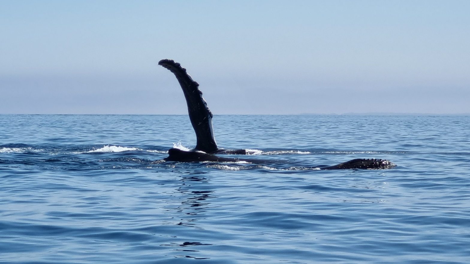
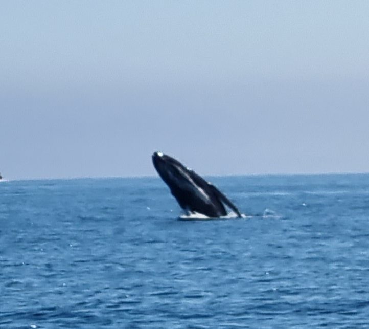
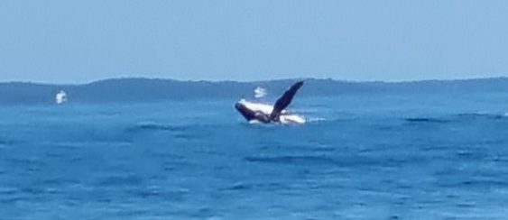
On the Monday after we got to Hervey Bay we headed out on our friends boat to do some whale watching, What an awesome day it was. perfect weather, awesome company and heaps of whales, dolphins, amd stingrays to be seen.
A compilation from our day on the water (sorry about the unsteady cameraman)
After a few more days relaxing and spending time with our best friends we headed to the town of 1770 on Friday 23rd September for a few nights.
On the way, we of course HAD to stop in at the Bundaberg rum distillery for a sample and some supplies!!!!!
On the Saturday we caught up with some more friends also on holidays there and went to explore the nearby Eurimbula National park for the day. It was an easy drive but managed to have some fun playing in muddy holes as well.
On Sunday we did a Family Kayak tour in the morning (the kids were no help paddling) around the inlet where we fed the fish and saw lots of wild life before having a nice morning tea on one of the sand banks. In the afternoon we relaxed at our friends apartment and ate to much cheese and nibbles!!!
Monday morning we went for short walk up to the headland and then to the museum. The museum is a great little place with tons of things to look at and an abundance of info on Captain Cook and the area as well.
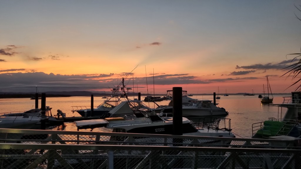
For dinner we headed to the marina to eat and watch the sunset ending our time in 1700 in the best way possible.
We stayed at Captain Cook holiday village which had nice big shady unpowered sites where we were and heaps of cabins as well as plenty of powered sites. The staff were really friendly and happy to help.
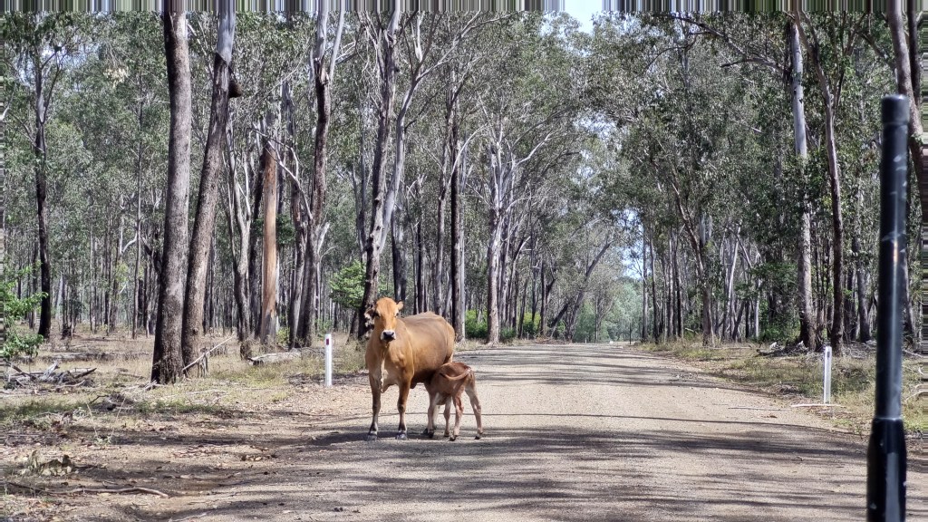
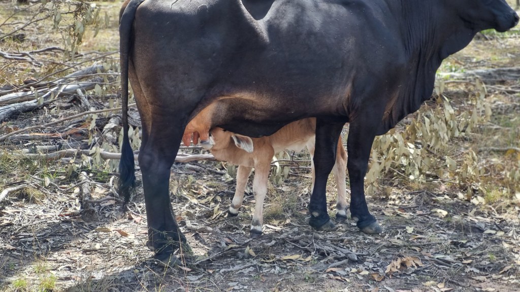
Tuesday 27th September we left 1770 and headed to the very small town of Ubobo in the Boyne Valley which is only a bit over an hour away and from there we planned to explore the nearby national parks. The Discovery centre in Ubobo is a great spot to camp all the facilities and friendly volunteer staff.
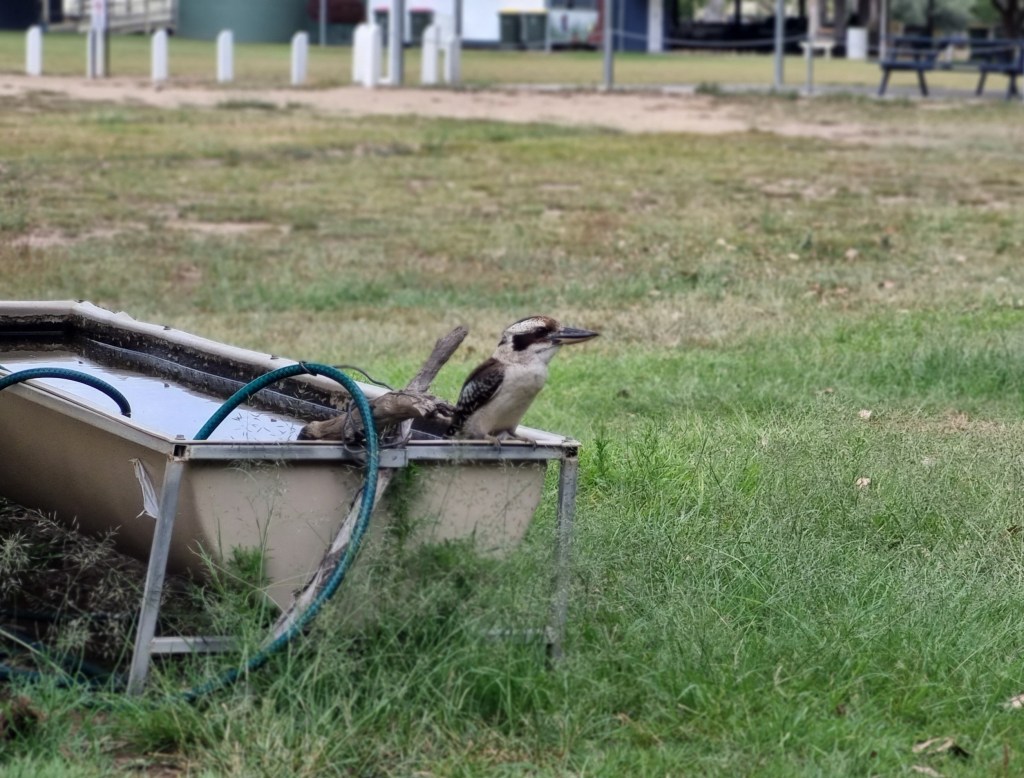
Kookaburra at our camp
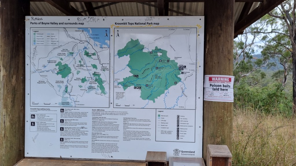
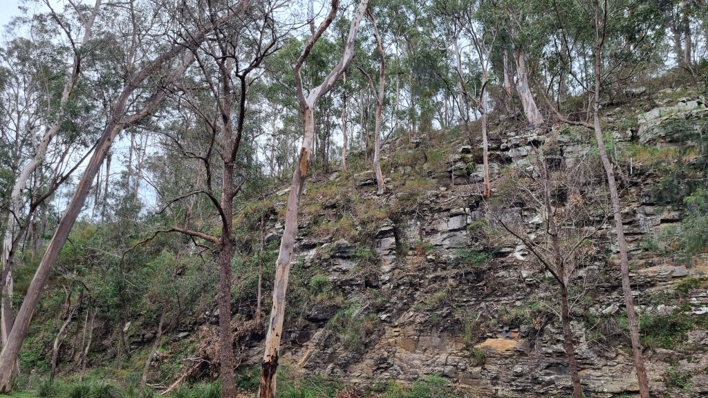
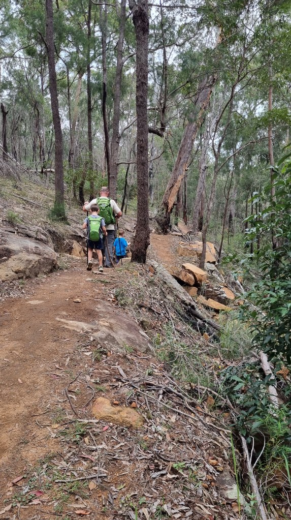
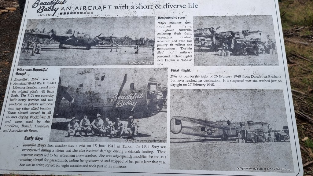
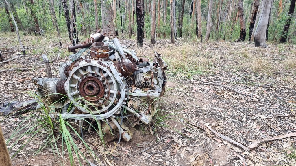
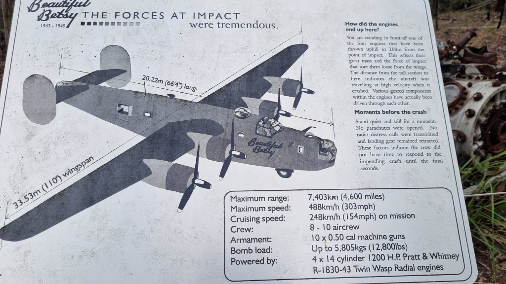
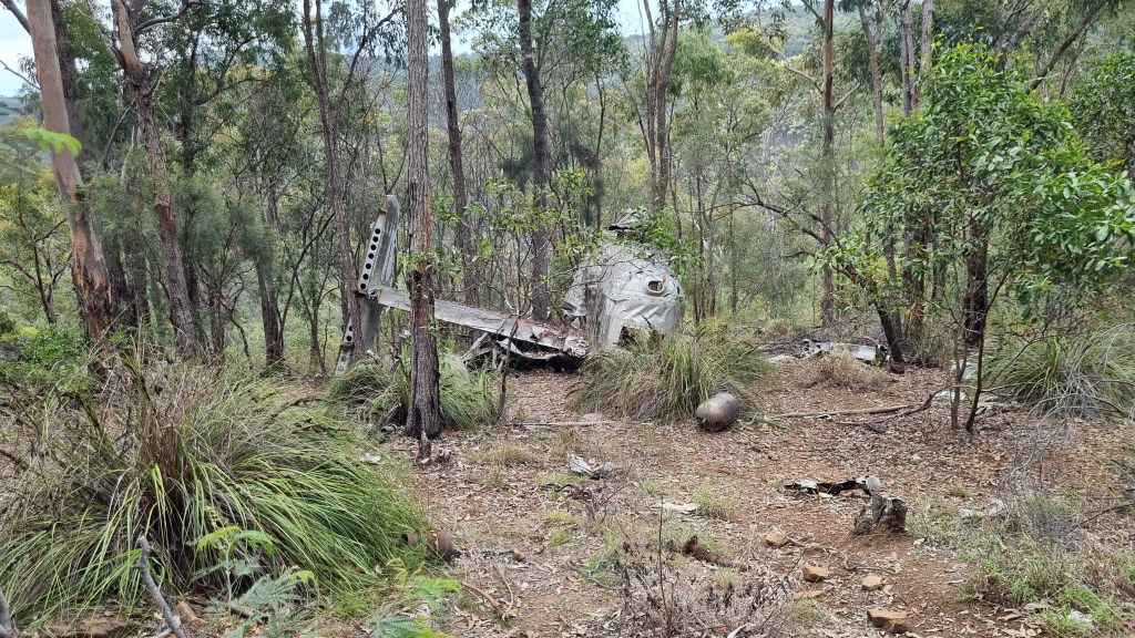
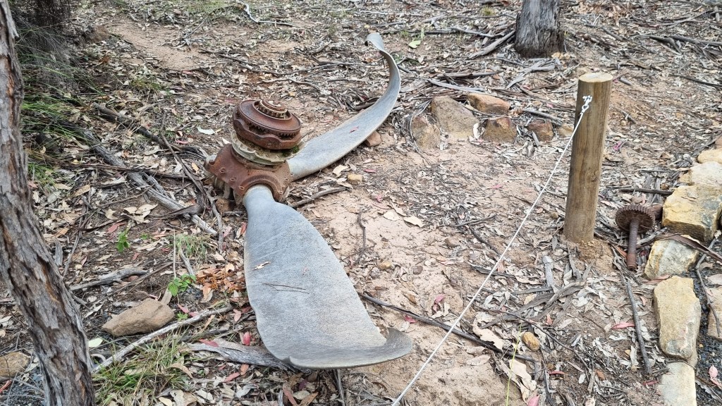
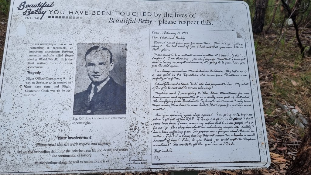
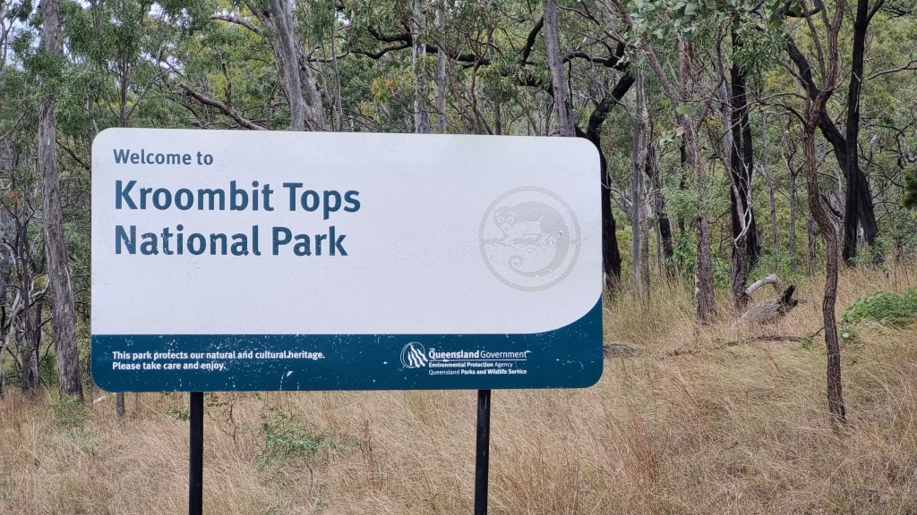
Wednesday we did a day drive to Kroombit tops National park and did the hike to see Beautiful betty. Betty was a lancaster bomber that crashed there in 1945 on its way from Darwin to Brisbane, sadly killing all 8 on board. The wreck is incredibly well preserved with everything still left when it settled. It was a nice not to hard walk but you will need a proper 4wd to get to the car park as it is at the bottom of a very steep descent.
Unfortunately our stay on the Boyne valley had to be cut short as the Patrol had developed a nasty sounding squeal from the engine bay and we had organised to get it looked at in Gladstone on Friday. So Thursday morning we slowly packed up and headed to Gladstone an hour away where we are staying at the showgrounds.
Unfortunately we found out Friday that the squeal coming from the patrol is a much bigger problem than hoped……. The turbo has S#*t itself. so looks like we are stuck here for a few more days to get it fixed. The mechanic said hopefully he can get it done by Tuesday or Wednesday (monday being a public holiday).
Stay tuned for part 2 of our adventure in a few weeks or so.
See the below links for our recorded travels on a ma
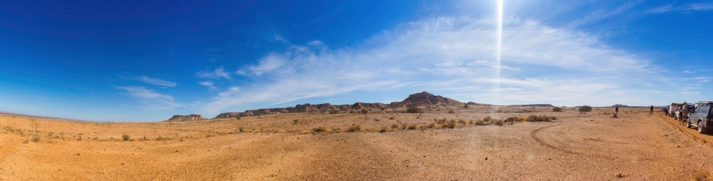
During the Easter school holidays in 2019 we along with some others from our local 4wd club did a trip to Uluru via Coober Pedy and back through painted desert and along the Oodnadatta track in 10 days.
The first afternoon was just a short 2 hour run up to Horsham where we stayed on a property owned by a friend of one of the club members. from there on day 2 it was a big drive from Horsham to Lochial in South Australia. The day was broken up with regular stops for toilet breaks and to let the kids stretch their legs. On this trip we had both our boys, one 4 and the other 6 months old at the time. One of the other family’s on the trip also had a 3 year old and a baby as well so in addition to the usual stops there was of course from time to time the emergency nappy change stop.
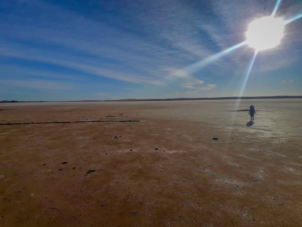
In Lochiel we camped out the back of the community hall which offers free camping and is directly across from the mostly dry salt lake. There are toilets there but no showers.
Lake Bumbunga, Lochiel
sunset from our camp
Day 3 saw us off early again and stopping in Port Augusta for lunch and to resupply on fresh food as fresh fruit and Veg are not allowed to be brought from Victoria into south australia. after that it was a straight run up to Coober Pedy for the night. The scenery changes quite a lot as you head north and it is easy to see why this area is such a hard place to live. Very dry and rocky ground that stretches on for mile after mile.
On arrival at the caravan park it we discovered that when the booking for our group was made the staff misunderstood when they were told we had 8 vehicles 5 with campers. We were booked into an area designed for those small 2 person camper vans not large camper trailers. As the caravan park was fully booked we just had to make it work which we did (good thing we were all friends). Due to problems with thefts, the caravan park is fully fenced and the gates are locked at night to stop people coming in and taking campers stuff.
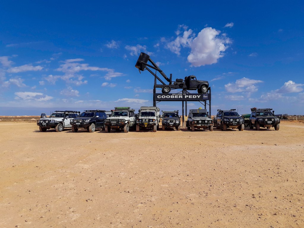
We spent the next morning exploring Coober Pedy, checking out the main street and the museum. While there is a lot to see in Coober Pedy we were happy with what we saw just up and down the main street. If you are really into gemstones or prospecting you could probably spend weeks here.
Our group at Coober Pedy
After an early lunch we all posed for the compulsory photo in front of the sign and headed north again, stopping at Cadney homestead for fuel and to book a table for the group on our way back before crossing into the Northern territory and to Erldunda roadhouse for our last stop before reaching Uluru.
Erldunda Roadhouse is a great place to say for the night with basic but good quality facilities, an emu & Kangaroo enclosure next to the caravan park and a great raised sunset viewing area (get there early for a good position). The kids had a ball looking at the Emu’s and kangaroos in the late afternoon.
Day 5 and we were all excited to get going this morning and for the whole way from Erldunda to Yulara, we were all excitedly looking out the windows for that 1st glimpse of Uluru. as it is only about 250km from the intersection of the Stuart Hwy at Erldunda to Yulara we arrived in time for a late lunch and after setting up, did some exploring of the resort.
Ayers Rock resort is a large complex with everything from camping to 5 star resort facilities. As we were there during the Easter school holidays it was very busy and we were in the overflow camping area. This was actually better for us as a group as it is one large open area and allowed us to all set up together.
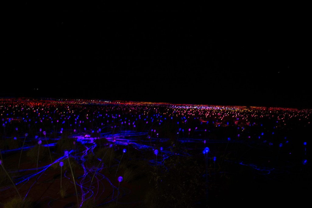
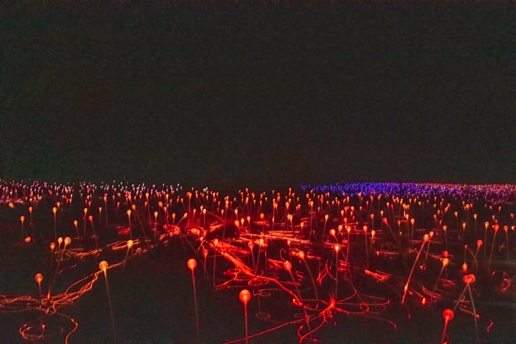
The 1st night at Yulara we did the Field of lights tour. This was a light installation done by an artist made of hundreds of thousands of LED lights. It was nice to see but dont think I would recommend personally as it was quite expensive. It was also a shame I couldn’t get any good photos as no tripods were aloud so most of the pics are fairly blurry.
The next morning I did a sunrise Segway tour around Uluru which was so much fun. It started with some breakfast by the rock of coffee, muffins and cereal. Then some Segway riding training before we were off on a guided trip all the way around Uluru. It was a great tour, the guide was excellent and I only almost fell off once. Not the cheapest activity but well worth it for me.
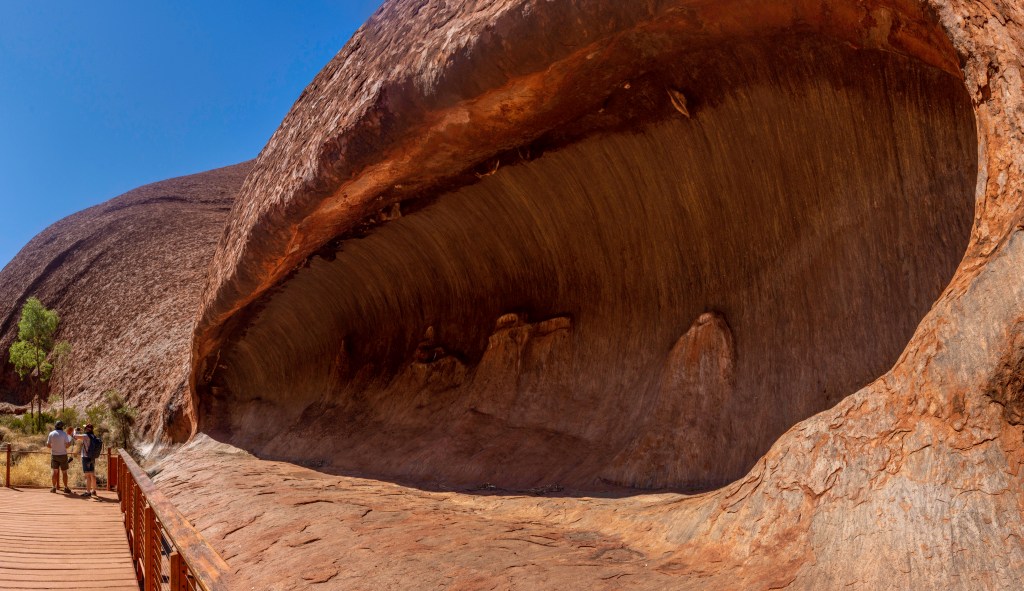
After returning to our camp late morning and having lunch, it was back to Uluru with the whole family for some more exploring. With a 4 year old and a 6 month old we didn’t go all the way around but explored some of the areas near where the climb route was (Climbing the rock is now prohibited), and found some small cave areas and a nice walk in the shade of the rock.
The next morning it was the wife’s turn to go and do the Segway tour while I stayed back and entertained the kids. WSe explored the resort, found the playground for a play (very important!!!) until lunch time.
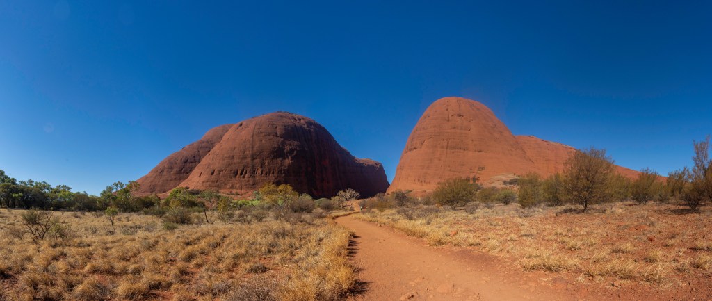
After lunch all 4 of us headed to Kata Juta ( the Olgas) for the afternoon to explore. There are some great walks in the area, some long and some short. With the small kids we only did one of the shorter ones but that was still a great time heading in between the massive rocks to a lookout ares. Our 4 year old particularly had a great time running up and down the path, over the rocks and bridges.
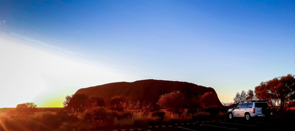
After spending a few hours there exploring, we headed back to the Uluru Viewing point for sunset before arriving back at camp for dinner and an early night after another big day of exploring.
Sadly the next morning it was time to pack up and slowly start heading homeward, so after a final quick goodbye to the rock we were on our way back towards the Stuart Hwy and then down to Cadney Homestead for the night. The facilities at Cadney homestead are clean and in good condition, however unfortunately the service left a lot to be desired. Our booking that we made on the way up was quite a large one as it was for everyone in the club that was on the trip and the restaurant forgot about it and we were told we would just have to wait when the error was identified. We were eventually able to place our orders but when the food did arrive, most of the meals were missing parts, such as the burgers did not have half the things listed on the menu. When we questioned this we were simply told they had run out of some of the ingredients. Now I do understand that we are in a remote area and that it is a lot harder to get things, especially fresh produce at times. The thing that really upset us and the rest of the group was that nothing was mentioned when we ordered, and no apology was given, the only response we got was that’s all we have. My recommendation if travelling through this area would be to stop at one of the other roadhouses north or south of here for far better service.
Day 9 and it was onto the dirt and across the painted desert before reaching Oodnadatta for an Oodna burger for lunch. This is a nice section of track, rocky but not to rough. We only had 1 flat tyre in the group which was caused by not screwing the valve back in fully when lowering the tyre pressures.
Somewhere along the track I had managed to rip the anderson plug off the back of the car and needed to get a new on in Oodnadatta so the camper would charge. Lets just say you definitely pay a premium out here for parts.
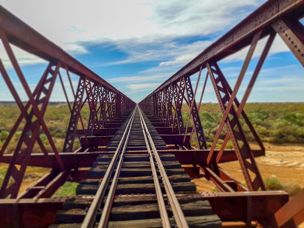
We continued down the Oodnadatta track stopping a couple of times at different sites like an old railway bridge on the original Ghan railway route before finding a place to camp off the side of the track. It was surprisingly soft off to the sides and some of us almost got bogged (almost).
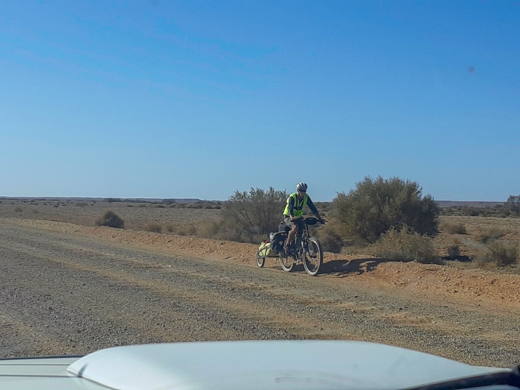
The Track was in very good condition when we travelled through, but just watch out for crazies on the track. (those people that feel the need to fly past your at high speed even though you can not see clearly ahead). One thing we did notice was that a lot of the road trains will drive down the road often on the wrong side so that the huge amount of dust they kick up blows away from the track not across it. They are also on the radio making sure others are aware of this. We also saw a couple of people riding their push bikes down the track.(not my idea of fun but each to their own).
It was a beautiful clear night around the fire on the side of the track with some great company.
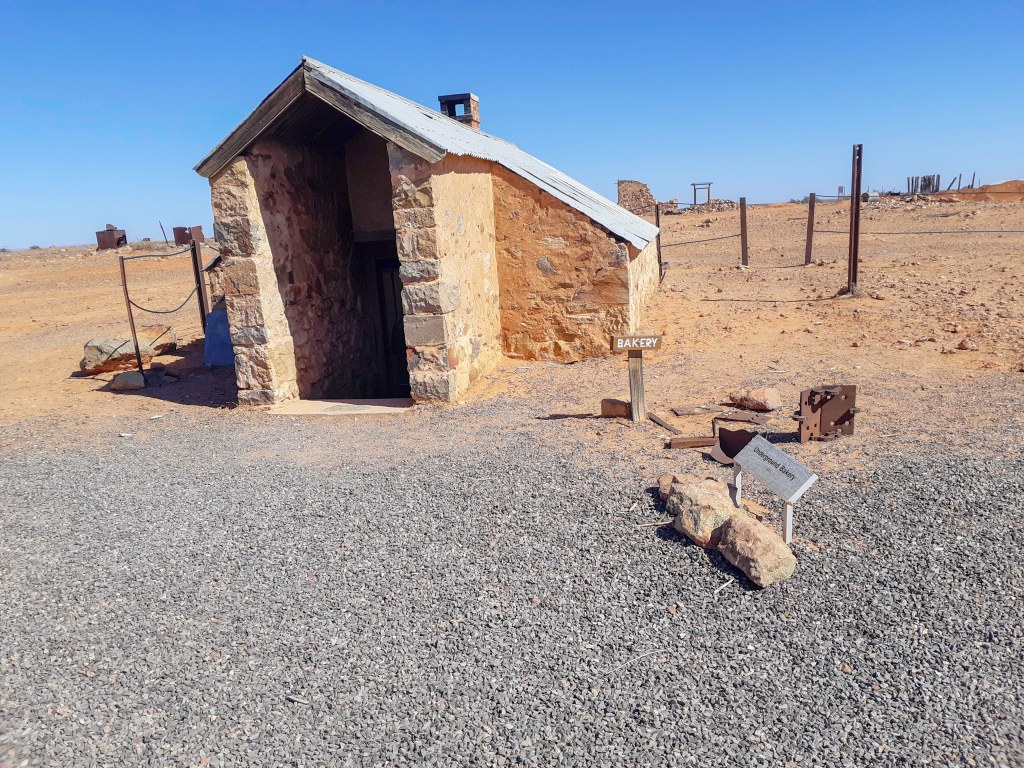
Day 10 and the 2nd last day of the trip. From our camp we headed back down the track and into Maree for morning tea and a look around. Maree is an interesting place with lots of history. Old trains to look at, Tom Cruise’s postie truck (no not the actor) and the lake eyre sailing club. From there it was down to Farina, another historic place now deserted. The beautiful old buildings are slowly being restored and for a few weeks a year June-July the community group actually open the old bakery and sell bread and other items. Unfortunately we were not there at the right time to buy some.
We pumped the tyres back up at Farina and it was back on to the bitumen for the run to Burra for our last lights stay at the recreation reserve. Good spot to stay with hot showers and toilets for quite a small fee. That night we went to the pub with one of the other couples for dinner and a drink as we didnt feel like cooking on the last night.
An early start on the last day as it was A big drive home from Burra and after packing and then unpacking and repacking the camper (someone couldn’t find the car keys!!!) we were off.
It was a quick but wonderful trip with some good friend and showed us how much is really out there in these remote areas of Australia. Can’t wait to go back and spend more time exploring this area.
As I have probably said before, the Victorian High Country is a wonderful place summer or winter and this trip is another fun time exploring a small section of this great part of Australia.
For this trip we actually stayed in a cabin at the local caravan park as we were arriving late on friday night and it was just simpler for only 2 nights with 2 young kids. The cabin was basic but clean and that’s all we really need.
Lake Eildon lookout
On this drive we had 5 4wds and picked up another tag along along the way. We left Jamieson at about 9am and headed out, past the brewery and up past the lookout to lake Eildon before turning off onto the mount Terrible track. After airing down the tires we all set off up the track. The main track is not particularly difficult and a standard $wd would manage it fairly easily however, over most of the peaks along the way were alternate routes going straight up and over the peaks rather than around them so of course most of the time we took those for a bit more fun.
Hitting the tracks
Some of these alternate tracks were very steep and in a couple of places quite slippery as well, the surface changing from compact dirt to loose shale and back to compact dirt again. It was at times hard to tell what the downhill sections were like as we were in the cloud most of the morning and couldn’t see more than about 30m in front of us. This made life interesting when we were part way down a very steep section and the surface changed to loose shale and we just had to keep the car straight in the tracks and guide it down while letting the engine braking control the speed until the grip increased again. In these conditions the worst thing you can do is stand on the brakes as the wheels will simply lock up leaving you with no control at all.
Taking the fun way up
About 11am we reached Mount Terrible which apparently has a great view however as we were still in the clouds we didn’t get to enjoy the view here. There is however a nice hut here which is worth a look.
Great view today…….
From here we continued along the Mount Terrible track towards Ryans hut stopping for lunch in a nice clearance beside the track (we had Pies cooked in the pie oven).
Mt Terrible
After lunch we continued on to Ryans hut before heading down into the valley and towards Enoch falls. Ryans hut is unfortunately completely covered in graffiti. Why people feel the need to deface these lovely old alpine hut is beyond me. you come to the bush to enjoy the outdoors, enjoy the driving so why destroy places with pointless graffiti and other damage. It is acts like these that cause these areas to be closed and the first people to whine about it are usually the ones that caused the damage in the first place.
Following the Big River rd along the valley to Enoch falls we stopped at the day area and walked up the track to the falls themselves. It is a short 700m well formed track to the falls and although I would have called them rapids more than falls they still look very nice with plenty of water flowing down the river..
Enoch falls
From here we continued on the Big River rd until we reached the bitumen again, pumped up the tyres and headed back to Jamieson.
That night we all headed to the Jamieson Brewery for dinner. It is a great pub and the meals are excellent, I can highly recommend a drink and a meal there if you are ever in the area.
Another fun weekend exploring an area we had not been to before but will definitely return to in the future.
Back in 2012 I finally completed one of those dream trips I had been wanting to do for a very long time. Mt everest base camp and also Island peak.
This is not an easy trek as the altitude alone will stop you dead in your tracks if not fit enough to manage the reduced oxygen levels but I guarantee all the preparations, and all the struggles will be worth it to see and experience such an amazing place.
For this trip I trained on average 4 days a week um in the Gold Coast hinterland doing day hikes. I started small with a light pack over a distance of 5km, and slowly increased the weight and distance until I could do 15-20km hikes with a moderate pack in about 2.5-3 hours. I did them at this pace purely from a fitness perspective rather than just for the enjoyment of the hike itself as I remembered from my New Zealand trip how much the altitude effected me then and did not want to be hindered by that again.
2 weeks before I was due to leave for Nepal I managed to inflame my kneecap on a hike (not good) and after seeing the doctor, the only recommendation was to rest it.
I figured I had spent all this money and done all the training for the trip so I would still be going, sore knee or not and just deal with it. So I rested for the last 2 weeks, packed and repacked more times than I care to admit, and hoped I would be fine when the trekking began.
The day had arrived so It was off to the airport for the flight to Kathmandu via Singapore. The flights were as expected uneventful, filled by sleeping through movies and eating dodgy airline food.
The stopover in Singapore was an experience having never Travelled overseas further then New Zealand before. What a massive terminal, with everything you could want including a cinema and hotel. It was only a 3 hour stopover so i spent the time there just looking around the shops.
On arrival in Kathmandu I was greeted by an unexpected sight, Monkeys in the gardens, around the terminal and even between the planes and the terminal area.
The terminal was just chaos, people everywhere and very little sense of organisation that I could see. Once I found the customs area I was able to get through there fairly quickly as I had organised my visa in Brisbane before departure. The line for those how did not already have a visa looked like it would take hours to get through. Then on to the security screening area where there were people just waving us through straight past the screening machines, I hope they were airport staff as they did not seem to be wearing anything to indicate they worked there.
I made my way out the front attempting to dodge all the people trying to get me a taxi or carry my bags, and thankfully as I got outside I saw someone waving a sign for World expeditions which was the company I had booked with. There must have been people there from at least 30 different tour companies there.
I waited until all the other people arrived before we were all directed to a waiting van to take us to the hotel. getting to the van may seem a simple thing, however this is Kathmandu and due to the amount of vehicles our guides could not get past the other vehicles with our gear, so they simply pushed the nearest car out of the way, loaded our stuff and pushed the car back into its park again.
For anyone who has not travelled in asia or india, travelling by car though Kathmandu (and a lot of asian countries) is a death defying experience in itself. If there are any road rules, no one seems to follow them. To make a right hand turn the driver would just turn into the oncoming traffic and slowly push his way through until clear again. It also seems quite normal to travel down the wrong side of the road to overtake even with multiple lanes of oncoming traffic.
When I was there a lot of road widening was being done, so most roads were either dirt or full of potholes. To widen the roads, the government simply took the fronts off all the buildings to make the roads wide enough, so as we were travelling through Kathmandu we could see straight into peoples houses.
Our accommodation in Kathmandu was at the Radisson which was very nice and very cheap compared to the same standard in most western countries.
That first night everyone on the tour met as a group for the first time for a drink at the bar and then to a nearby traditional restaurant for dinner. The food was excellent with a mix of curries, breads, and rice dishes. Some were a little hot for me but the flavours were just fantastic and the momo’s (dumplings) are awsome. From there it was straight to bed after a long day of travelling.
Day 2 was a relaxing day of sightseeing around Kathmandu. A morning tour took us to both Hindu & Buddhist sites which were both great experiences. First the Shri Pashupatinath Hindu temple situated next to the Bagmati river. By the river are numerous Cremation Pyres and once the bodies and fires are burned to ashes, they are swept into the river to be carried to the next life.
The Temple itself is magnificent, the spire is solid gold and the main door is made of silver. We were unable to enter the temple itself as only Hindu people are permitted.
From there we headed off to the Boudha Stupa. We are told that this Stupa is over 1200 years old and that when it was built, the King commanded that all the water to make the cement was to only be collected from the morning dew and because of this, it took 12 years to build.
All around the Stupa are shops, cafes and galleries. In one to the galleries was a representation of the stupa made with coloured sand by the Dalai lama himself.
After lunch we headed into the shopping district of Thamel to hire our climbing boots and explore. Thamel has street after street of shops full of everything you could think of. Countless souvenir, clothing, and equipment shops. Most of the small clothing and outdoor shops sell poorly made copies of the big name brands but there are larger stores selling the genuine products as well. It was generally fairly easy to tell the fakes by the quality, despite the operators assurances that they were genuine.
Getting back to the hotel across the main road is interesting to say the least. to get across the multiple lanes of traffic you need to just start moving across through the traffic and hope they stop for you. We learned quickly to cross as a group or with some of the locals.
On the way back was one of those sights you just don’t ever forget. Part way back we noticed 2 male police officers in full riot gear walking across the road holding hands. Of course this looked to us very much out to the ordinary, however as we learned during our time in Nepal, holding hands is much more a sign of friendship not romantic relationships.
The third day sees the start of the real adventure. Up at 5.30 for breakfast then onto a bus at 6.30 for the trip to the airport although it turned out there was no need to get there so early as the aircraft that were to take us into the mountains had been stuck at Lukla all night due to poor weather in the mountains.
We finally departed a bit before 10am and what an amazing flight (unless you don’t like flying). Flying at around 12000ft and looking out first at the farmlands and then the ever increasing terrain until we were flying through low passes with 5000 an 6000m mountains towering up around us. Flying through the last few passes the ground was only 100m or so either side of the aircraft.
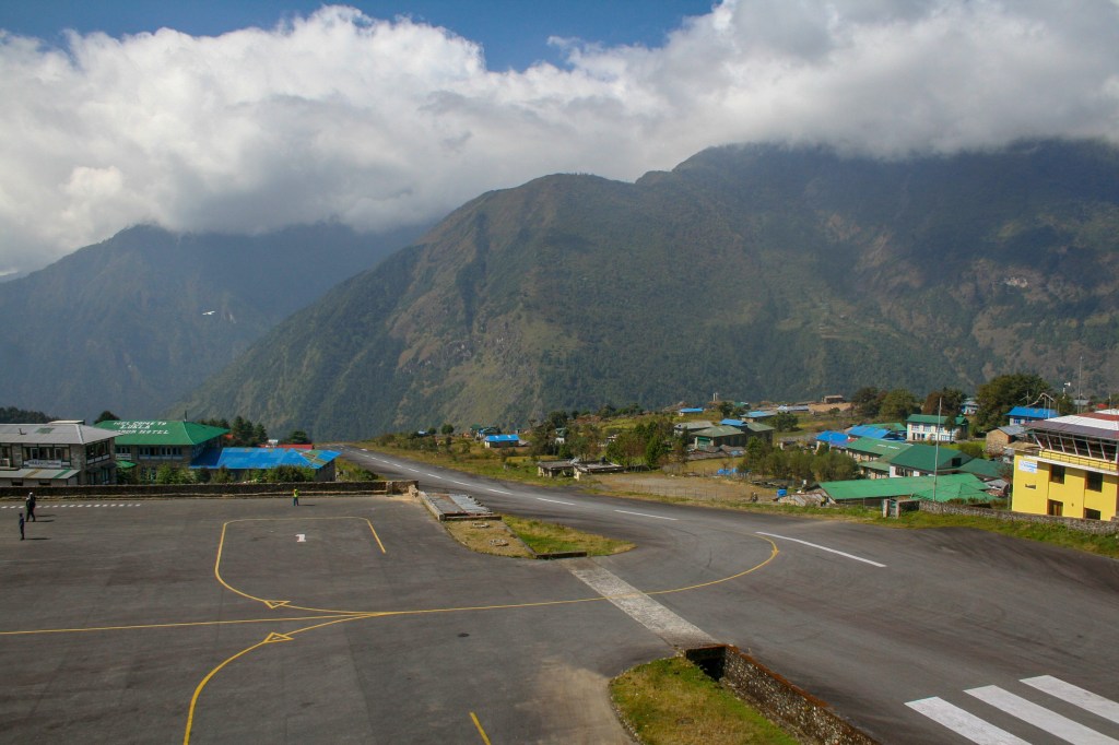
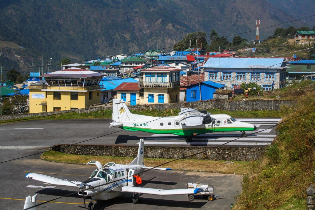
Lukla airport is the one on the top of every dangerous airport show I have ever seen and it looks even steeper in real life. Landing the uphill slope helps to slow down and we turn into the parking area while still slowing so we don’t hit the wall on the end of the runway.
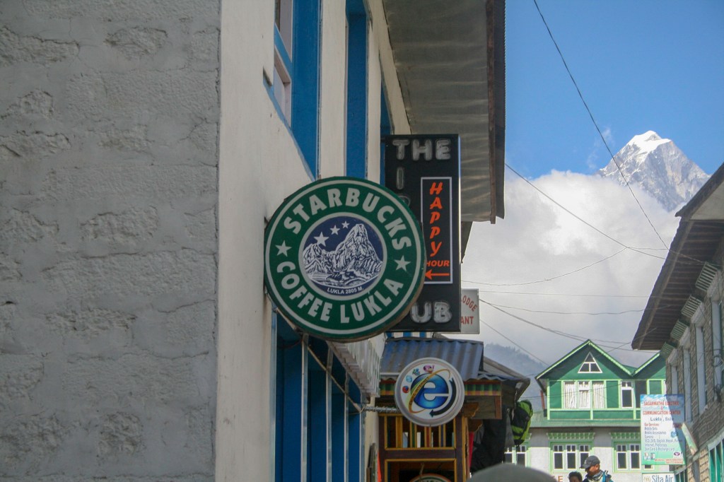
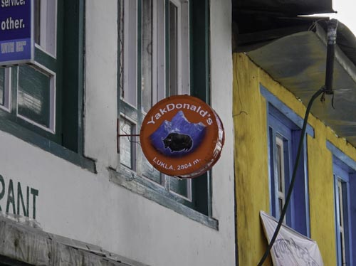
In Lukla we met all our guides and sherpas and had a short amount of time to look around before we were to start the trek. Of all the things you might expect to see and a small mountain town with no road access, an Irish pub and a Starbucks are not among them.
It was a relatively easy start to the trek with a short 2 hour mostly downhill walk to our 1st camp in Ghat. This was one of the permanent campsites we were using which have large tents with foam mattress beds and a stone building used for dining and socialising. In the afternoon I took a small walk down to the Dudh Kosi (milk river) before heading back for afternoon tea and dinner.
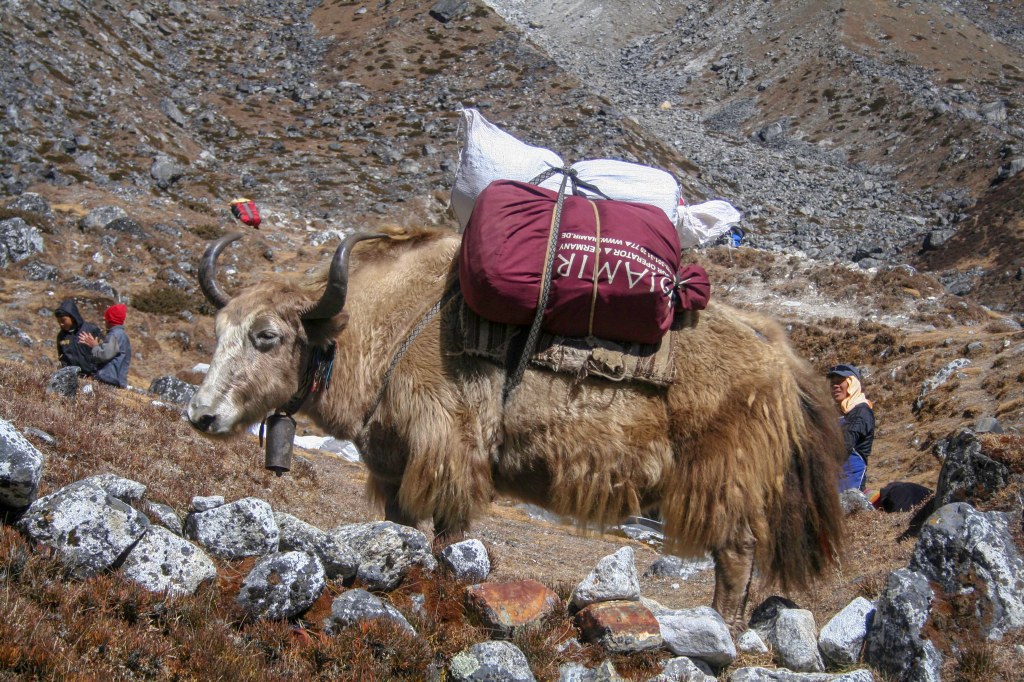
The next morning we were woken at 6.30 by the Sherpas bring us tea in bed and a bowel of warm washing water. After a quick breakfast it was on the trail again towards Monjo. These lower sections of the track are very busy with tourists like us, guides, porters and yaks all moving up and down the track carrying everything from hikers gear to food, timber and other supplies to the villages up the track. Some of the loads are huge and it is just astounding that these people are able to carry such loads at such altitudes and with such apparent ease compared to the struggles we already had not being used to the altitude.
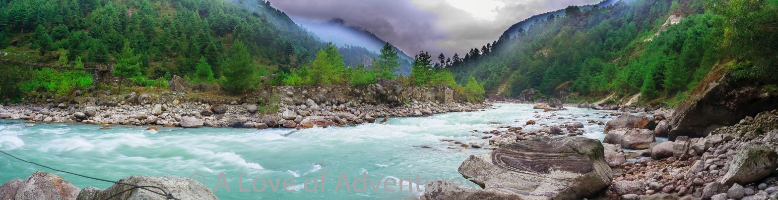
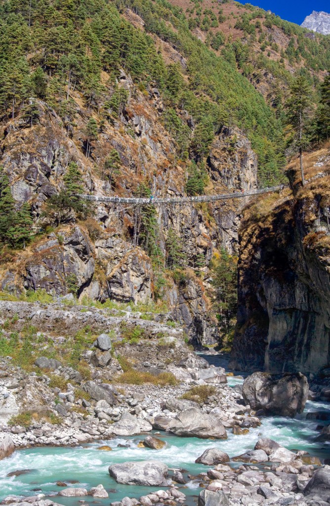
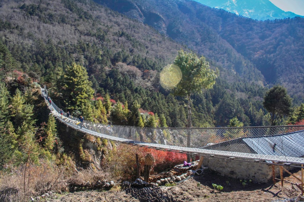
The trail follows the Dudh Kosi along the valley going up and down with the terrain with several crossings of the river. The suspension bridges are made from steel cable and aluminium boards and is the only way across so everything on the track uses them including the Yaks and horses. It was a fairly short day today arriving in Monjo at about 1pm for a late lunch and time to relax and have some hot chocolate at a local café.
The buildings we have at each of the camps for meals are simple but comfortable buildings all with a heater fuelled by Yak dung. Dried Yak dung is used as there is a severe shortage of wood and a lot of deforestation in the area. Ye Yak dung burns very hot and keeps the building nice and warm for us although you do not want to leave the door to the fire open to long as there is quite a smell to the smoke.
Everyone on the trip is appreciative that the first couple of days are a bit easier which is giving us time to acclimatise a little before the bigger days and steeper climbs.
The 5th day of the trip and 3rd on the trail was to be the first big climb day where we would go from Monjo in the valley at 2800m to Namche Bazaar up at 3465m. We started just after 8am and continued along the valley near the river for an hour or so doing up and down with the track. Because of the altitude even now every uphill is hard work as we are still adjusting to the lower oxygen levels.
At the base of the main climb of the day we stopped for a break and could see the very high bridge ahead. (this bridge is no longer used and a new one even higher has replaced it)
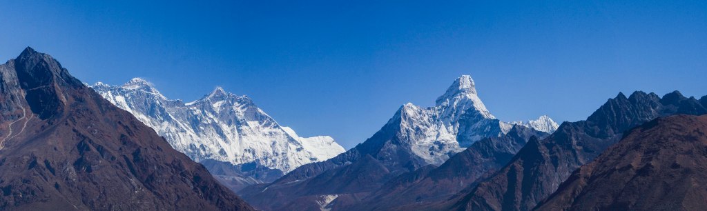
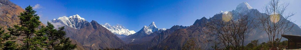
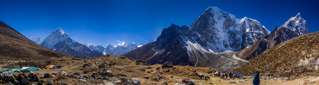
The climb from the river to Namche Bazaar is only just over 3km but is a constant climb of over 600m vertically and it took us about two and a half hours to get to Namche. This was a very hard climb for me as I was really feeling the altitude having no where in Australia anywhere near these heights to practice. About half way up the climb is a rest area which also gives you the 1st view of Mt Everest itself.
Finally reaching Namche Bazaar I thought thank god we are here only to be told our accommodation was “up there” which was sill quite a long way above our current position and at above the town itself. We all pushed on and reached the lodge in time for a late lunch of pasta and grilled spam (yes spam!!!). The afternoon was spent checking out Namche Bazaar and getting supplies (read chocolate). A few of us spent some time in a café as well before heading back to the lodge. The lodge had 1 shower and came at a cost of 400 rupees ($5) but I thought it was worth it given that there likely wouldn’t be the opportunity for another one for a while. The hotel Sherwi where we stayed here also has a Sherpa culture museum which is definitely worth a look, the owner showing us through and explaining many different artefacts used by the Sherpa people now and in the past.
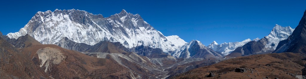
Day 6 was to be a “rest” and acclimatization day. After breakfast we headed out on a walk up to the nearby Everest View Hotel. This is a climb of 400m in altitude and took about an hour and a half to get there. The view towards Everest is breathtaking, looking up the valley you can see Mt Everest, Lhotse, Nuptse, and Ama Dablam.
After a coffee, it was back to our lodge in time for lunch and a relaxing afternoon of cards and an early night.
In the morning it was an early start to continue up the track. The first few hours were relatively easy with just small ups and downs and views of Mt Everest and Lhotse ahead of us. As we got closer to the Dudh Kosi we descended through a scenic moss covered pine forest to where lunch was waiting for us by the river and by the time our lunch break was over I had just about fallen asleep.
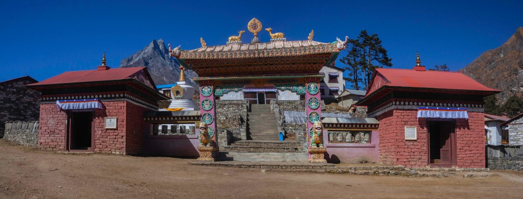
After waiting for a herd of yaks to cross the bridge over the river, we headed across and started up the long steep climb to the Tengboche Monastery. About 2/3 of the way up the hill it started to snow lightly, a nice light dry snow.
On arrival at the Monastery we were given a tour through some of the areas. I found the tour extremely interesting although chilling on the feet as no shoes are permitted inside.
After leaving Tengboche Monastery it was just a short mostly downhill walk to our next camp at Deboche, arriving just in time for afternoon tea.
Apart from the night in Namche Bazaar, washing yourself involves a bowl of warm water which the sherpas bring to your tent and a cloth to give yourself a sponge bath in the tent. Thankfully this day by the time we arrived at camp the snow had stopped falling so it was not quite as cold as it could have been. Today was the first day that it got properly cold during the day and of course I didn’t have an extra warm layer in my day pack so I had to wait til we got to camp to get to the rest of my cloths which the porters carry for you so you are only carrying a light day pack.
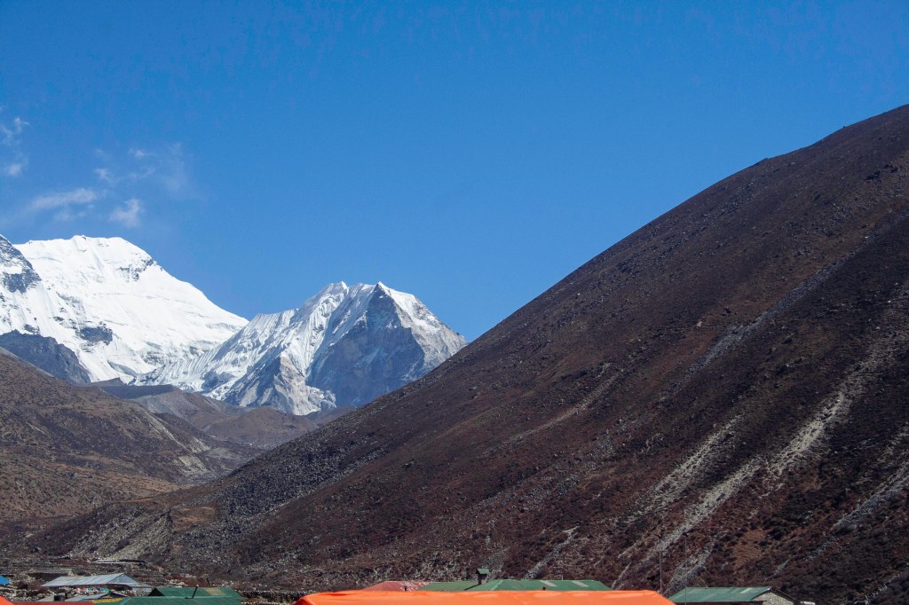
Early rises are becoming the norm now and after a breakfast of porridge and pancakes we hit the trail again. The morning was mostly a gentle uphill walk reaching 4000m in altitude just before lunch. The thing you notice as you get higher is the change in vegetation and by 4km above sea level the trees have almost completely stopped growing. Lunch was tuna and vege pasta with a cinnamon scroll for dessert. From there it was a short walk to cross the Dudh Kosi again before the steep climb up to Dingboche began. A steep and rocky track full of switchbacks and plenty of people on their way down having a little chuckle at our struggles coming up.
Our camp at Dingboche sits at just over 4300m altitude and offers amazing views up the valley all the way to Island peak which we are to be climbing in about a weeks time, and after the struggles just to get to this point I was looking up at this mountain and the only thought that came into my head was “what the fuck was I thinking”.
This would also be our last permanent camp until returning to Dingboche on our way back down again.
Day 9 was a rest day in Dingboche and I woke to a crystal clear sky and views forever. After an omelette breakfast, some went for a walk up a nearby hill for some acclimatisation while most including myself stayed in camp and relaxed. About mid morning I went for an explore through the village which is mostly a collection of tea houses and lodges. I came across a “french Bakery” and decided to have a hot chocolate and a snickers roll. They tasted ok and it was nice and warm inside the bakery.
The higher we go, the harder I am finding it to sleep, so after the bakery I took the opportunity for a bit of a nap before lunch, oh and another one after lunch too. Another trick I have learned on this trip is that drinking water bottles work really well as hot water bottles in your sleeping bag. This also has the double effect of still having water to drink in the middle of the night instead of ice.
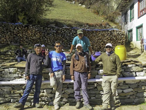
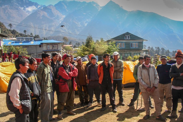
Time to talk about our guides. Bir Sing was our head guide, a very professional and knowledgeable and friendly guide, whatever he said goes among the guides and porters. Sonam was one of our climbing guides and has a lot of big mountain experience. He is a real character, always having a joke or playing funny tricks. Vishnu was our head sherpa, he worked tirelessly throughout the entire trip bringing us tea in our tents, serving meals, organising washing water, and even brought me back to Dingboche when I got sick before heading back to the rest of the group and bringing several more back when they also got sick. There were also a lot of porters, cooks but we did not see a lot of them as they usually headed off ahead of us to setup the next camp before we arrived. I believe in total there were 28 staff in total for the 10 of us on the trip.
The permanent campsites we have been staying at until now have been great, with large tents and mattresses on frames as well as heated dining halls. Each of these had cushioned seats and a yak dung fueled heater, most also had electricity for lighting as well. But after leaving Dingboche until we return here after Island peak, we will be in dome tents with a large tent for eating.
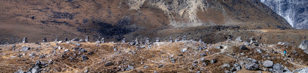
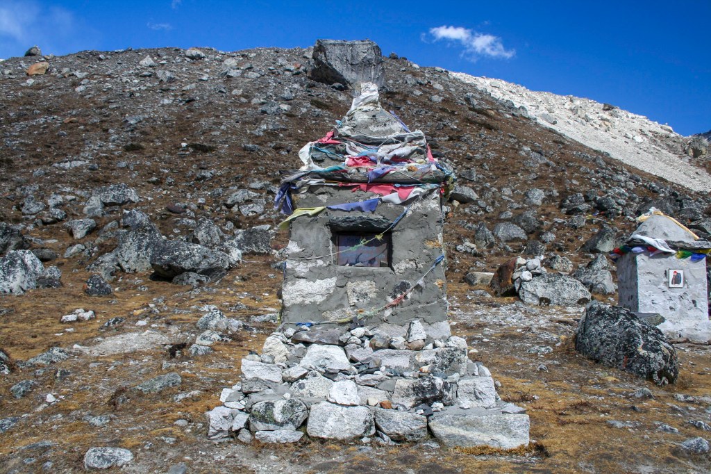
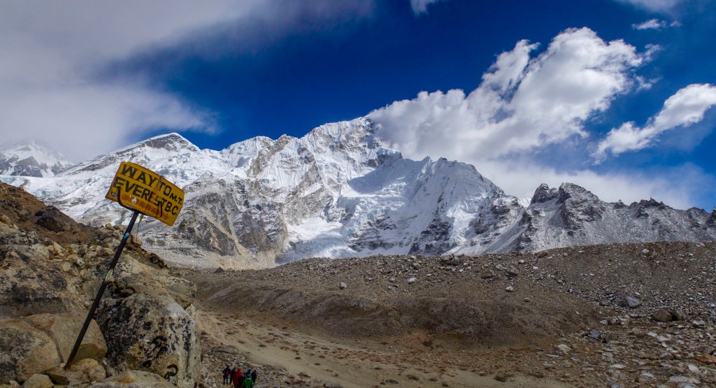
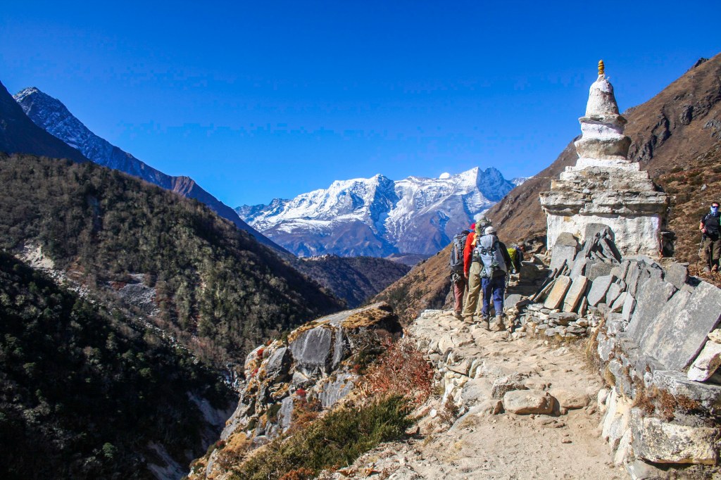
We left Dingboche on the morning of day 10 and trekked up the side of the valley towards the base of the Kumu glacier before crossing the river and climbing up the other side of the glacier towards the village of Lobuche. Reaching the top of the climb to the left side of the glacier we passed an area of memorials to climbers who had died on Mt everest and other peaks in the area.
A line of Chortens to remember those who have died on the mountains
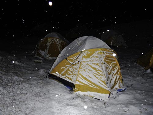
Lobuche is a very small village about halfway up the valley towards Mt Everest base camp and we camped just outside the town. It got down to -12 this night in our tents but tucked up with thermals, hat water in our drinking bottles and a good sleeping bag provided by the tour company, I was nice and warm.
Day 11 is the day. Lobuche to Gorak Shep and Mt Everest base camp. We left camp by 8am and headed up beside the glacier. This was hard work on a mostly 1 land track, twisting through the moraine beside the glacier, climbing up and down, and squeezing past people and yaks. I was really struggling with the combined effects of a bad cold which seemed to be getting worse and the altitude. We reached Gorak Shep about 11.30 for lunch before heading to base camp.
not far to go
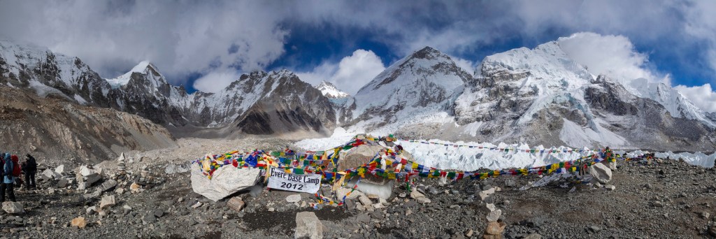
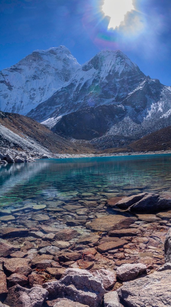
This last stretch was incredibly difficult for me as my cold was making it a lot harder to breath in the thin air and it took 2.5 hours to get from Gorak Shep to Mt Everest base camp at 5345m above sea level. The track was rough and the last part was on the glacier itself which does not look like the nice clean glaciers people imagine, rather is covered in rubble and larger rocks as well as being pitted with crevasses. When I finally made it to base camp it was all worth it. The views are spectacular up the glacier to the Kumbu icefall and Mt Everest peeking out from behind the closer Nuptse. The whole valley is surrounded by these massive mountains towering above you even though we are already standing at well over 5000m above sea level.
The view from base campI made it
The Kumbu icefall that the climbers must go through looks truly frightening, near vertical in parts, these multi story chunks of ice move slowly down the mountain to join the Kumbu glacier and can topple over without warning.
Kumbu Icefall
After a rest and the compulsory photo taking, we headed back to Gorak Shep where we were camping for the night. By this stage I was so buggered that I had to get one of our guided to carry my pack for me. This helped a little and after getting back to camp and having dinner I just passed out in the tent.
The next morning, most of the group got up early to climb Kala Pattar, a nearby hill that gives excellent views of Mt Everest. As I still not feeling very well, I decided to stay in camp and rest and take a few photos.
Gorak shep
While I was at camp I saw 2 helicopters looking for someone further up the valley. At this altitude the helicopters need almost full power to land and can carry very little. Due to the altitude the pilots also have to use oxygen at all times when flying.
After lunch at Gorak Shep we all started heading back towards Lobuche before crossing the glacier to our camp at the base of Kongma La(pass). The trip across the glacier was a real struggle with steep ups and downs on ice, loose rock and dirt. Climbing the short steep sections I was gasping for breath so much it felt like I was suffocating which was making it hard for me to focus clearly. We reached the camp site around 5pm and were greeted with a daunting view looking up to the top of the pass 600m in altitude above us. The climb looked like it went up at a 45 degree angle and was made of shale and loose rock.
After waking in the next morning and feeling no better it was decided that I would head back down to Dingboche and wait there for the rest of the group to return there after climbing Island peak. I wished everyone good luck with the climb and headed back to Dingboche with Vishnu and 1 porter and the next day we would decide if I was feeling well enough to return to the group via a different path. On the way back down I got to see the very start of the Dudh Kosi as it emerged from the Kumbu glacier. After an afternoon rest I was there to greet another group arriving in camp on their way up to base camp. Because the rest of my group and all the support staff were in a different place, I went down to the nearest lodge for diner where I had tuna and yak cheese pizza(different!!!). It actually tasted pretty good.
Island peak
In the morning I was still feeling pretty bad so I decided to stay in Dingboche while Vishnu and the porter headed back up to the rest of the group. This gave me a really good day of rest which did me the world of good. During the day I also went into town and found a place to have a shower which only cost 350 rupees and well worth it and the floor warmed up once the hot water melted the ice off it.
Dingboche is mostly just a collections of lodges and tea houses and each place seems to have a shop, internet place or bakery in the front as well for anyone passing through to stop at.
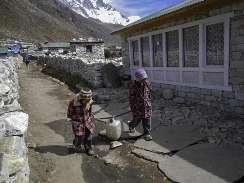
Kids carrying water in Dingboche
Heading up into the mountains I expected there no phone service or internet anywhere but it turns out the phone reception is better up here than with some providers in major cities in australia and most villages have at least 1 internet cafe. It is funny to see porters carrying these 50-70kg loads up these mountains chatting on their phones like they are just on a leisurely stroll down the street.
The morning of day 15 I was woken by one of the kind lodge staff asking if I would like some tea. I didn’t want any and eventually crawled out of bed and went down to the lodge for an omelette and hot chocolate. After breakfast and a wander through the village, I arrived back at the camp to find a number of bags had turned up for a group. I checked a couple of the tags and it was the gear for some of the others in my group a day earlier than expected. It turned out that a majority of the group had also suffered from illness and 1 injury going over Kongma La and had to come back down, leaving only 3 to attempt the climb of island peak. With most of the group back in Dingboche means my meals will be back in the camp dining room with the group.
Yak
Day 16 was another very relaxing day of reading, relaxing and exploring the village. While in the village we got some supplies (chocolate) and stopped at one of the bakeries for coffee and cake before heading back to camp for lunch. In the afternoon we headed back into the village to listen to a talk on ASM (altitude sickness) before dinner and bed. The last few day in Dingboche have helped dramatically and am feeling so much better.
Day 17 was another day of waiting as the 3 remaining group members were not due back from Island peak until tomorrow but since most of us came back to Dingboche early we took the opportunity to do a half day trip up to the nearby Ama Dablam base camp. Before we headed off on the day trip we all met up in the hall for breakfast although due to the effects of the altitude none of us were very hungry and didn’t eat much. We felt sorry for Vishnu who has worked so hard to look after us all, making sure our food is brought to us and is different whenever possible. He looked so upset when most of us hardly ate anything for breakfast.
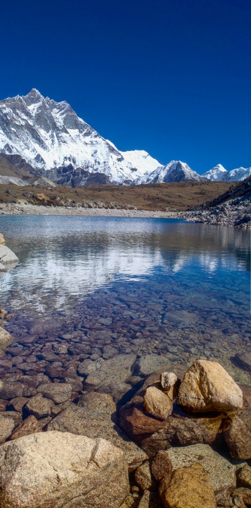
270 view from Ama Dablam base camp
The climb up to Ama Dablam base camp was a very steep but thankfully fairly short climb on the other side of the valley to our camp. The views here are great with perfect views of Ama Dablam, Lotse and Island peak. Even with the steep sections to climb, my breathing was a lot better today thankfully. We explores the area for a bit before heading back to camp for lunch and and afternoon of cards and a lay down in the warm sun soaked tent.
Lotse & Island peak (Island peak sounds big at 6200m until seen beside Lotse at 8400m)
Island peak(left) Ama Dablam(right)
Day 18 and time to start the trek back down from the big mountains. It was a late start for us as we had to wait for the last 3 to join us from Island peak so after packing our gear we all spent the morning sunbaking and trying to spot the others coming back down. They arrived about 12 and we all congratulated them on the achievement as the only 3 of the group to make it up the mountain. After a leisurely lunch we all left Dingboche together for a short downhill walk to Sonare which would be our last night in the dome tents. Over dinner that night the 3 that reached the top of Island peak told us all about the climb and the struggles of going up and down the ropes, trying to pass others going the other way on the very sharp ridges.
Day 19 was a fairly big day from Sonare to Namche Bazaar. It started with some small ups and downs before a steady climb up to Thyangboche Monastery. 2 weeks ago this would have been a much tougher climb but now that we are much more acclimatised it was actually fairly easy. After a few more photos outside the monastery we headed down the big hill to the river and our stop for lunch. While the descent is easy from a fitness perspective it was causing no end of pain for my inflamed kneecap and I found myself relying more and more on my walking poles to take the weight off the knee during the downhill sections. Lunch today was at a tea house next to the Dudh Kosi which is a great spot although all we all wanted to do as a group is get to the lodge in Namche Bazaar which was our destination for the evening. Another climb away from the river after lunch seemed so easy compared to the struggles in the same area on the way thanks to being acclimatised and after a brief stop at a bakery for afternoon tea, we reached the lodge at 4pm. I dropped my bags in the room and headed into town to pick up a few small souvenirs.
One of the many bridges over the river(left), Stupas on the track(right)
Another early start for our 2nd last day on the track. Up at 6.30 and departed by 8 but not before organising a sweep for the Melbourne cup which was on the same day back home in Australia. Going down the big descent to the valley floor from Namche Bazaar really hurts the knee but I was prepared for it and took some painkillers before departing and that helped immensely. We all moved quickly this morning and before we knew it we were half way down the descent and at the point where we got our 1st and now last view of Mt Everest. Continuing down the hill, across the high bridge over the Dudh Kosi and along the valley beside the river, we arrived at Gaht which was where we stayed on the 1st day at about 3pm.
Day 21 our last day in the mountains. A short 2h walk up to Lukla and I think we all raced up the last little bit once we spotted the archway at the start of the track and headed to where we met the porters at the start of the trek. It felt good to be finished the trekking part of the trip but a little sad at the same time.
Arch at the start/end of the trek
After lunch we made our way to the lodge for the night and got excited that they had showers, only to find out shortly after that there was no hot water. Oh well one more day wouldn’t kill us. after finding our rooms and dumping our bags, we all headed back to see our main guides to thank them for everything they had done for us. Vishnu had broken the strap on his pack the day before and one of the ladies on the trip kindly donated her pack to him. A genuine brand name pack would be well beyond what the guides would be able to afford so was a wonderful gesture on her behalf. I gave one of the climbing guides a couple of carabiners that would be useful to him on climbing expeditions in the future. We also all put in some cash that was divided up among all the guides and porters as a thank you for all their hard work. They were all very thankful for the gifts as we were for all they did for us. We said our goodbyes to most of the guides and headed back to the lodge. After dinner we all headed to the Irish pub in Lukla for a a drink or two (yes a very unusual place for an irish pub).
Farewell cake from the lodge in Lukla
Day 22 was a 5am start so we were packed and ready for the 1st flights out of Lukla to go back to Kathmandu. Our guide headed to the airport and would come and get us when it was time to go (the airport was just across the path from our lodge), Although 10 minutes later he came back in a hurry and told us we had to go now as there was heaps of people there and we had to get checked in and through security. It turned out that there was a lot of extra people there due to a number of flights the day before being cancelled due to poor weather in the areas between Lukla and Kathmandu. Just like Kathmandu airport, Lukla was chaos having to push our way through the crowds to get to the check in and security. Thankfully our tickets were already organised. Once through security we watched the planes arrive in quick succession and no sooner had the stopped, they were loaded with bags and passengers and were taking off again. The whole process taking no longer than 5 minutes. As soon as our plane landed we were ushered out the door and to the plane as the people arriving were still getting off. Before we knew it we were on and the plane taxiing to takeoff again. The takeoff is amazing, Rolling down the runway you really get a perspective of how steep it is looking out the windows and seeing the angle of the buildings compared to the downhill run of the plane. The flight out, just like to one in was a nice scenic flight looking out at the mountains and then farmlands as we got closer to Kathmandu. After collecting our bags we were back at the hotel by 9am.
Planes departing Lukla
After a very long shower and shave I went to the bar and got a nice big burger for lunch then spent the rest of the day sorting out gear and getting clothes cleaned before meeting up with everyone for dinner.
Day 23 the last day of the trip. It was a nice relaxing day spent wandering around the area, checking out the many many shops in the touristy shopping district of Thamel before meeting the group and head guide for a celebratory dinner at a restaurant called Rum Doodle in Thamel. It was good to see everyone together for the final time and we took the opportunity to thank Bir Sing our guide for all his efforts.
Day 24. Up and breakfast before one last walk around near the hotel. My flight was in the afternoon so I was able to see some of the others off in the morning as they left for their flights and just relaxed until my checkout at 12pm. The departures area was a lot more organised than when I arrived, and after checking in and going through security I watched the planes (and the monkeys) coming and going until it was time to board for the long flights home. The 1st hour of the flight was good, looking out at the mountains I was trekking through a few days before until they faded into the distance.
Another interesting restaurant in Lukla
This was an absolutely amazing experience of a lifetime that I will never forget. It was incredibly hard work with a pit of pain and suffering, but worth every minute of it. Hopefully I will be able to return one day in the future and take my family with me so they can also experience this truly unique area.
I would like to thank all the staff from World Expeditions who I did the tour with, both in the office who were incredibly helpful with information and advice on preparing for the trip, as well as the local staff who guided us, fed us and carried our gear up and down the mountains. Everyone involved was easy to deal with and made the trip the amazing adventure it was.
After an early dump of snow on the Victorian and NSW High country we packed up the swag and headed up to the mountains to try and find some snow to play in. This trip I had my 7 year old son with me and another friend was well in his car.
The original plan for this trip was to head through Mansfield and up to the Howitt High Plains and then to the Wonnangatta valley. This however didn’t happen as most of the tracks we had planned to use were closed a week early before the anticipated storms that were to bring the snow. The plan was amended to still go through Mansfield, but instead of the original route, we would head north into the mountains, cross some rivers and end up in the Buckland valley to camp.
After stopping at the Mansfield bakery for a pie and some bread rolls, we headed north through to Whitfield where we turned Right towards Dandongadale. From there on to the dirt and to just past Abbyyard where we were to cross the river and climb up over the range and into the Buckland. This was not to be as the river crossing was fairly deep with a strong current. River crossings can be fun but it is very important to ensure it is safe to cross and on this occasion we decided it was simply to deep and to fast moving to try. So back we went along the Abbyyard rd and then continued north into Myrtleford and heading into the Buckland Valley from Porepunkah.
Thankfully we only had the swag this weekend so it was a nice and quick setup and get a fire going to keep us warm. Dinner was nice and easy, hotdog’s cooked in the jetboil on the fresh rolls from the bakery.
Camping by the Buckland river
The next morning it was off for a fun day of 4wding, river crossings and snow. We continued up the valley, crossing the Buckland river several times (thankfully this one was not as deep as the other one) before winding our way up the Mt Murray track to the top of Mt Murray where we found the most snow.
one of the crossings of the Buckland river
This trip was on the opening weekend of the ski season, and despite all the weather in the days before we headed up there, the snow was not particularly deep and only above 1500m in altitude. Getting to the top of Mt Murray was an enjoyable but not difficult climb, the tracks were wet but in good condition and we used low range gearing only because it made life easier on the river crossings and up the steeper twistier sections.
Coffee time at Mt Murray
After a play in the snow and a coffee, we headed off again following twin jeeps track back towards Mt Hotham.
Back at the main road it was time for lunch as the pies were ready in the pie oven before heading off back down the main road towards Harrietville. Before reaching Harrietville we took a small detour down the Old Coach Rd, this track is actually much straighter than the main road but after the rain was a little slippery on the steeper sections.
At Harrietville we turned left straight back on the to the dirt tracks to wind our way back over the mountains and down Pleasant creek track and back to the Buckland river. Across the river and back to camp by about 3.30 in the afternoon. Time for a drink and some nibbles by the fire.
Crossing the Buckland river
Sadly The next morning we had to pack up and head home but it was a fun weekend and my son really loved the swag and the snow, and everything else come to think of it!!! even though it was a little wet and cold.
Travelling with 2 small children creates all sorts of fun and challenges. One of those is clothing storage.
We have tried a few different options, bags, soft collapsible shelves but these always had problems. As we are towing a camper trailer on most of our trips we would have space to put the clothes storage when setup but would also need to pack them in the camper or 4wd when on the move.
Bags are simple and easy to store but particularly with the kids cloths we found them to be annoying and hard to keep organised and find things. The kids would also just drag things out and mix them all up.
Soft hanging collapsible shelves. Good in concept but for us did not work well at all. The hanger at the tops were not strong enough for the loaded weight and they tended to lean forward under the weight of the clothes making them all fall out. (not ideal). They also had to be packed laying down so the clothes didn’t fall out.
Storage boxes. We got some 5 drawer plastic storage drawers from the cheapy shop and made them up but with only 3 drawers each due to the packing height limitations, one for each family member. When the camper is setup these stack 2 high and side by side leaving plenty of floor space in the camper. When packed they go 2 deep and 2 wide in the back of the 4wd. For us this works quite well overall as the clothes are well organised, easy to find and less likely to get all mixed up. when packed in the 4wd, they doo take up more room than bags would however with all the cooking, water, fridge, food and sleeping gear in the camper we do not need to put heaps in the 4wd.
Clothes drawers
have now settled on plastic drawers, one for each family member
The NSW snowy mountains are a beautiful area at anytime of year. There are so many areas to discover.
You can walk to the top of Mt Kosciuszko from either Charlottes pass or from Thredbo. Thredbo is the easier and shorter route at just over 6km each way as you catch the chairlift to the top of the ski field and walk from there.
From Charlottes pass following the main track up and back is a little over 9km each way. Or from this direction you can follow the main range walking track to Blue lake lookout and back to Charlottes pass from there. This circuit is about 22km.
This time however I decided to walk up from Charlottes pass and then ski down from the top and around the southern side of mount Clarke back to the river crossing on the Blue lake track.
It was a nice morning although a little harder than normal carrying my ski gear. The below photo was taken from the bridge crossing the Snowy river part way along the track.
Snowy river looking towards Mt Kosciuszko taken from the bridge
Not long before I did this day trip we had had dust storms over a lot of the east coast which left a layer of dust on everything as evident by the colour of the snow.
looking north from the track a little higher than the river crossing
A rest at Seamans hut and a couple of photos before heading the rest of the way to the top.
Having my skis on my back did get a few looks from other hikers being mid November but although there wasn’t complete snow cover the snow drifts still looked big enough to ski down most of the way although not following the track down.
Seamans Hut (photo actually taken on a different trip)
By the time I decided to set off downhill, the clouds had come over making it a lot cooler. The snow wasn’t great but still fun and an achievement for me to ski off the highest point in Australia.
Following the slope down north and then around the side of Mt Clarke I managed to ski almost all the way back down to the Snowy river about 1km south of the Blue Lake track crossing.
Reaching the crossing I hadn’t thought about the river level with the amount of snow still around. Usually you can cross on the stepping stones almost all the way across, however this day the river was waist deep and freezing.
deeper than it looks
The only 2 options I had was to wade across or hike all the way back up to the bridge and cross there which would have taken a few hours with no track directly there from the western side of the river.
I decided to wade across as thankfully once across it is only a short walk up to the car park. I stripped off to shirt, underwear and shoes and slowly made my way across. I was shaking violently from the cold by the time I reached the other side (thank god I had dry pants to put back on).
As soon as I got back to the car I got the heater blasting to warm up.
Looking back towards the Blue lake track crossing from the carpark
It was overall a fun adventure that I have never forgotten.